
Geographic Region: USA-MICHIGAN
Feature: WHITEFISH BAY
|
Geographic Region: USA-MICHIGAN Feature: WHITEFISH BAY |
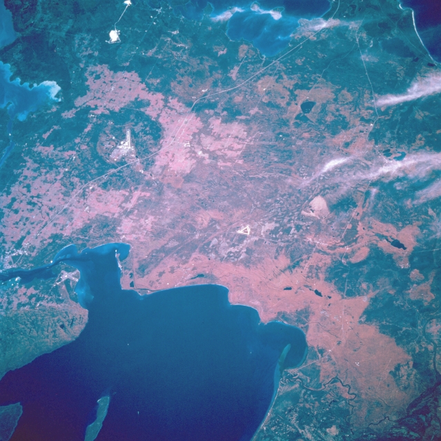 |
| STS068-207-109 Whitefish Bay, Michigan, U.S.A. October 1994 Whitefish Bay (bottom left), bordering the northern shore of Chippewa County in Michigan's Upper Peninsula, is featured in this south-southeast-looking, low-oblique, color infrared photograph. The agricultural, dairy, and lumber area south and west of Sault Sainte Marie (just below left center) also has commercial fisheries and many recreational resorts. Discernible are a portion of the Hiawatha National Forest (near center of photograph), Interstate Highway 75 between Sault Sainte Marie southward to Saint Ignace (not discernible), and two airports--the Chippewa County International Airport east of Interstate Highway 75 (left of center) and the Sault Sainte Marie Airport in Canada at the entrance to Saint Marys River from Whitefish Bay just west of Sault Sainte Marie. Parisienne Island is apparent in the middle of Whitefish Bay (near bottom left). |
| Images: | All Available Images Low-Resolution 353k |
|
| Mission: | STS068 |
|
| Roll - Frame: | 207 - 109 |
|
| Geographical Name: | USA-MICHIGAN |
|
| Features: | WHITEFISH BAY |
|
| Center Lat x Lon: | 46.5N x 85W |
|
| Film Exposure: | N | N=Normal exposure, U=Under exposed, O=Over exposed, F=out of Focus |
| Percentage of Cloud Cover-CLDP: | 5 |
|
| Camera:: | HB |
|
| Camera Tilt: | 44 | LO=Low Oblique, HO=High Oblique, NV=Near Vertical |
| Camera Focal Length: | 250 |
|
| Nadir to Photo Center Direction: | SE | The direction from the nadir to the center point, N=North, S=South, E=East, W=West |
| Stereo?: | N | Y=Yes there is an adjacent picture of the same area, N=No there isn't |
| Orbit Number: | 38 |
|
| Date: | 19941002 | YYYYMMDD |
| Time: | 182909 | GMT HHMMSS |
| Nadir Lat: | 47.6N |
Latitude of suborbital point of spacecraft |
| Nadir Lon: | 86.5W |
Longitude of suborbital point of spacecraft |
| Sun Azimuth: | 197 | Clockwise angle in degrees from north to the sun measured at the nadir point |
| Space Craft Altitude: | 117 | nautical miles |
| Sun Elevation: | 38 | Angle in degrees between the horizon and the sun, measured at the nadir point |
| Land Views: | FOREST |
|
| Water Views: | BAY |
|
| Atmosphere Views: | |
|
| Man Made Views: | AIRPORT |
|
| City Views: | |
|
Photo is not associated with any sequences | ||
| NASA Home Page |
JSC Home Page |
JSC Digital Image Collection |
Earth Science & Remote Sensing |
|
This service is provided by the International Space Station program and the JSC Earth Science & Remote Sensing Unit, ARES Division, Exploration Integration Science Directorate.

|