Geographic Region: RUSSIAN FEDERATION
Feature: SELENGA RIVER DELTA
|
Geographic Region: RUSSIAN FEDERATION Feature: SELENGA RIVER DELTA |
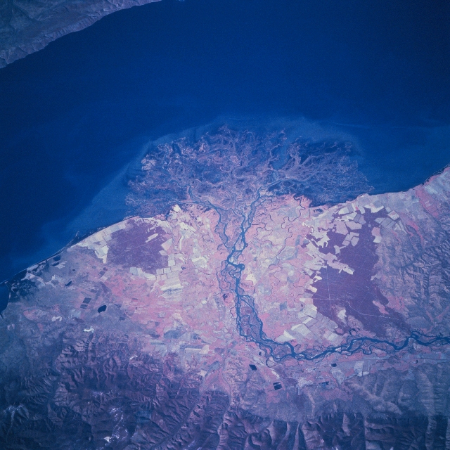 |
| STS068-206-040 Selenga River Delta, Russia October 1994 The Selenga River has deposited a sizeable delta along the southwest side of Lake Baykal. While over 300 streams flow into Lake Baykal, the Selenga River is the largest single river system that enters the lake. The Selenga along with many of its tributary streams and valleys provide transportation routes that connect Russia with Mongolia and China. Over 50 percent of the pollution that enters Lake Baykal enters through the Selenga River from as far away as Mongolia. Considering the depth of Lake Baykal (maximum depth 5710 feet-1741 meters) the amount of eroded sediment that has created such a large delta is impressive. The delta is a maze of interconnected waterways and wetland as expressed by the intermixing of colors and shapes (center of image). The dark red areas (green vegetation on this color infrared image) north and south of the braided channels of the delta of the Selenga River are forested land. The lighter-colored areas (towards center of image) show the extent of the agricultural activities (angular-looking field patterns) on the fertile delta. The delta area also provides an extensive wetland habitat for many species of fish, waterfowl, and mammals. The northern slopes of the rugged Khamar-Daban Mountains are visible along the bottom of the image. |
| Images: | All Available Images Low-Resolution 340k |
|
| Mission: | STS068 |
|
| Roll - Frame: | 206 - 40 |
|
| Geographical Name: | RUSSIAN FEDERATION |
|
| Features: | SELENGA RIVER DELTA |
|
| Center Lat x Lon: | 52.0N x 106.5E |
|
| Film Exposure: | N | N=Normal exposure, U=Under exposed, O=Over exposed, F=out of Focus |
| Percentage of Cloud Cover-CLDP: | 0 |
|
| Camera:: | HB |
|
| Camera Tilt: | 48 | LO=Low Oblique, HO=High Oblique, NV=Near Vertical |
| Camera Focal Length: | 250 |
|
| Nadir to Photo Center Direction: | NW | The direction from the nadir to the center point, N=North, S=South, E=East, W=West |
| Stereo?: | N | Y=Yes there is an adjacent picture of the same area, N=No there isn't |
| Orbit Number: | 45 |
|
| Date: | 19941003 | YYYYMMDD |
| Time: | 044932 | GMT HHMMSS |
| Nadir Lat: | 50.9N |
Latitude of suborbital point of spacecraft |
| Nadir Lon: | 108.4E |
Longitude of suborbital point of spacecraft |
| Sun Azimuth: | 184 | Clockwise angle in degrees from north to the sun measured at the nadir point |
| Space Craft Altitude: | 117 | nautical miles |
| Sun Elevation: | 35 | Angle in degrees between the horizon and the sun, measured at the nadir point |
| Land Views: | |
|
| Water Views: | DELTA, RIVER, LAKE |
|
| Atmosphere Views: | |
|
| Man Made Views: | |
|
| City Views: | |
|
Photo is not associated with any sequences | ||
| NASA Home Page |
JSC Home Page |
JSC Digital Image Collection |
Earth Science & Remote Sensing |
|
This service is provided by the International Space Station program and the JSC Earth Science & Remote Sensing Unit, ARES Division, Exploration Integration Science Directorate.

|