
Geographic Region: USA-TEXAS
Feature: HOUSTON AREA
|
Geographic Region: USA-TEXAS Feature: HOUSTON AREA |
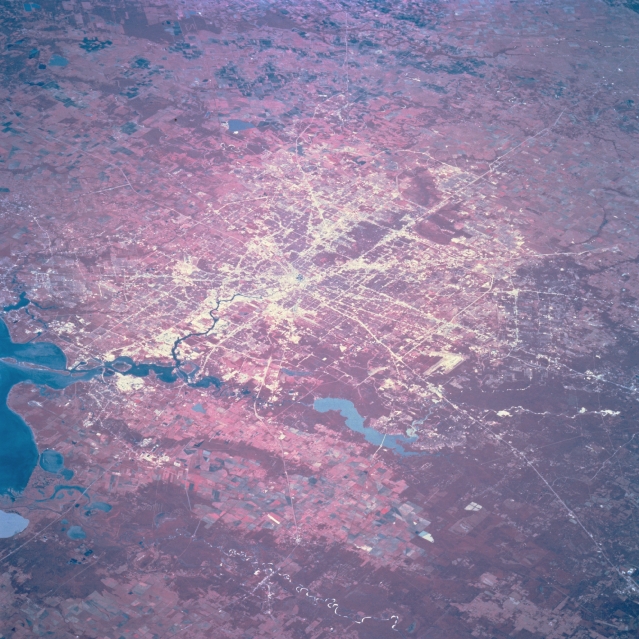 |
| STS068-205-020 Houston, Texas, U.S.A. October 1994 Highways radiate outward from the central business district of Houston, which lies on the flat, coastal plain of southeast Texas. Dense woodlands, primarily north and east of the city, are shown as deep reds with color infrared film. Blue Lake Houston (actually muddy brown) is part of the San Jacinto River that eventually flows into the northwest corner of Galveston Bay. Visible east of the San Jacinto River and its floodplain are slightly elevated cultivated fields that separate the San Jacinto watershed from the much broader floodplain and delta of the Trinity River drainage basin (near the bottom left corner). Lighter areas show larger concentrations of commercial and industrial activities. |
| Images: | All Available Images Low-Resolution 364k |
|
| Mission: | STS068 |
|
| Roll - Frame: | 205 - 20 |
|
| Geographical Name: | USA-TEXAS |
|
| Features: | HOUSTON AREA |
|
| Center Lat x Lon: | 30.0N x 95.5W |
|
| Film Exposure: | N | N=Normal exposure, U=Under exposed, O=Over exposed, F=out of Focus |
| Percentage of Cloud Cover-CLDP: | 0 |
|
| Camera:: | HB |
|
| Camera Tilt: | LO | LO=Low Oblique, HO=High Oblique, NV=Near Vertical |
| Camera Focal Length: | 250 |
|
| Nadir to Photo Center Direction: | W | The direction from the nadir to the center point, N=North, S=South, E=East, W=West |
| Stereo?: | N | Y=Yes there is an adjacent picture of the same area, N=No there isn't |
| Orbit Number: | 167 |
|
| Date: | 19941010 | YYYYMMDD |
| Time: | 171621 | GMT HHMMSS |
| Nadir Lat: | 31.2N |
Latitude of suborbital point of spacecraft |
| Nadir Lon: | 92.6W |
Longitude of suborbital point of spacecraft |
| Sun Azimuth: | 164 | Clockwise angle in degrees from north to the sun measured at the nadir point |
| Space Craft Altitude: | 111 | nautical miles |
| Sun Elevation: | 51 | Angle in degrees between the horizon and the sun, measured at the nadir point |
| Land Views: | PLAIN |
|
| Water Views: | CHANNEL, RESERVOIR, RIVER |
|
| Atmosphere Views: | |
|
| Man Made Views: | URBAN AREA, AIRPORT, HIGHWAY |
|
| City Views: | |
|
Photo is not associated with any sequences | ||
| NASA Home Page |
JSC Home Page |
JSC Digital Image Collection |
Earth Science & Remote Sensing |
|
This service is provided by the International Space Station program and the JSC Earth Science & Remote Sensing Unit, ARES Division, Exploration Integration Science Directorate.

|