
Geographic Region: USA-TEXAS
Feature: BEAUMONT, PORT ARTHUR, ORANGE
|
Geographic Region: USA-TEXAS Feature: BEAUMONT, PORT ARTHUR, ORANGE |
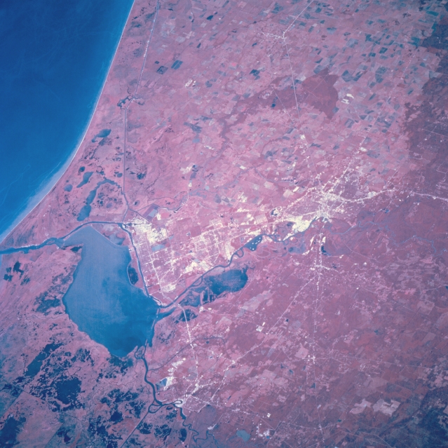 |
| STS068-205-019 Beaumont and Port Arthur, Texas, U.S.A. October 1994 The flat coastal plain in southeast Texas is the setting for Beaumont, Port Arthur, and Orange. The color infrared film helps to discriminate such features as the swampy, coastal prairies; red concentrations of woodlands (primarily pine); and land-water boundaries. Visible are the Neches River and its floodplain immediately east of Beaumont and Port Arthur; part of the dredged Neches River (Beaumont Ship Channel) that allows oceangoing ships to navigate inland to the port of Beaumont; and part of the Intracoastal Waterway that roughly parallels the coastline. The lower Sabine River is apparent entering Sabine Lake, which connects with the Gulf of Mexico via a dredged channel. Discernible are some highways in Orange (bottom center of photograph), large rice fields west of Beaumont and Port Arthur, and Interstate Highway 10 traversing Beaumont (top to bottom of photograph). |
| Images: | All Available Images Low-Resolution 344k |
|
| Mission: | STS068 |
|
| Roll - Frame: | 205 - 19 |
|
| Geographical Name: | USA-TEXAS |
|
| Features: | BEAUMONT, PORT ARTHUR, ORANGE |
|
| Center Lat x Lon: | 30.0N x 94W |
|
| Film Exposure: | N | N=Normal exposure, U=Under exposed, O=Over exposed, F=out of Focus |
| Percentage of Cloud Cover-CLDP: | 0 |
|
| Camera:: | HB |
|
| Camera Tilt: | 46 | LO=Low Oblique, HO=High Oblique, NV=Near Vertical |
| Camera Focal Length: | 250 |
|
| Nadir to Photo Center Direction: | SW | The direction from the nadir to the center point, N=North, S=South, E=East, W=West |
| Stereo?: | N | Y=Yes there is an adjacent picture of the same area, N=No there isn't |
| Orbit Number: | 167 |
|
| Date: | 19941010 | YYYYMMDD |
| Time: | 171616 | GMT HHMMSS |
| Nadir Lat: | 31.5N |
Latitude of suborbital point of spacecraft |
| Nadir Lon: | 92.8W |
Longitude of suborbital point of spacecraft |
| Sun Azimuth: | 163 | Clockwise angle in degrees from north to the sun measured at the nadir point |
| Space Craft Altitude: | 111 | nautical miles |
| Sun Elevation: | 51 | Angle in degrees between the horizon and the sun, measured at the nadir point |
| Land Views: | COAST, PLAIN |
|
| Water Views: | LAKE, RIVER, CHANNEL |
|
| Atmosphere Views: | |
|
| Man Made Views: | URBAN AREA, HIGHWAY |
|
| City Views: | BEAUMONT |
|
Photo is not associated with any sequences | ||
| NASA Home Page |
JSC Home Page |
JSC Digital Image Collection |
Earth Science & Remote Sensing |
|
This service is provided by the International Space Station program and the JSC Earth Science & Remote Sensing Unit, ARES Division, Exploration Integration Science Directorate.

|