
Geographic Region: USA-MICHIGAN
Feature: MARQUETTE AREA
|
Geographic Region: USA-MICHIGAN Feature: MARQUETTE AREA |
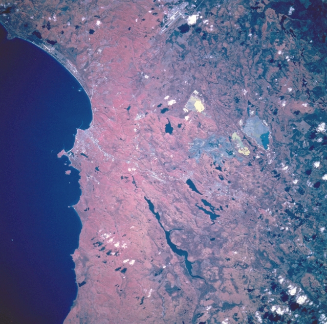 |
| STS068-203-020 Marquette, Michigan, U.S.A. October 1994 The Crystalline Uplands, the small port city of Marquette (left of center) on Michigan's Upper Peninsula, and Lake Superior are featured in this southeast-looking, low-oblique, color infrared photograph. One of the most scenic regions in Michigan, the Crystalline Uplands consists of old, resistant mountain cores that form part of a Precambrian shield extending northward into Canada. The terrain, sculptured into various forms by continental glaciation, has thin and infertile soil. Marquette serves as a lumber, iron ore mining and shipping, and resort center. Visible are the runways of K. I. Sawyer Air Force Base (near top center) and the long, snakelike Dead River Storage Basin (midway between center and bottom center). |
| Images: | All Available Images Low-Resolution 361k |
|
| Mission: | STS068 |
|
| Roll - Frame: | 203 - 20 |
|
| Geographical Name: | USA-MICHIGAN |
|
| Features: | MARQUETTE AREA |
|
| Center Lat x Lon: | 46.5N x 87.5W |
|
| Film Exposure: | N | N=Normal exposure, U=Under exposed, O=Over exposed, F=out of Focus |
| Percentage of Cloud Cover-CLDP: | 5 |
|
| Camera:: | HB |
|
| Camera Tilt: | 12 | LO=Low Oblique, HO=High Oblique, NV=Near Vertical |
| Camera Focal Length: | 250 |
|
| Nadir to Photo Center Direction: | W | The direction from the nadir to the center point, N=North, S=South, E=East, W=West |
| Stereo?: | Y | Y=Yes there is an adjacent picture of the same area, N=No there isn't |
| Orbit Number: | 86 |
|
| Date: | 19941005 | YYYYMMDD |
| Time: | 173147 | GMT HHMMSS |
| Nadir Lat: | 46.5N |
Latitude of suborbital point of spacecraft |
| Nadir Lon: | 87.1W |
Longitude of suborbital point of spacecraft |
| Sun Azimuth: | 178 | Clockwise angle in degrees from north to the sun measured at the nadir point |
| Space Craft Altitude: | 116 | nautical miles |
| Sun Elevation: | 39 | Angle in degrees between the horizon and the sun, measured at the nadir point |
| Land Views: | FOREST, FAULT, HILL |
|
| Water Views: | LAKE |
|
| Atmosphere Views: | |
|
| Man Made Views: | URBAN AREA, AIRPORT |
|
| City Views: | |
|
Photo is not associated with any sequences | ||
| NASA Home Page |
JSC Home Page |
JSC Digital Image Collection |
Earth Science & Remote Sensing |
|
This service is provided by the International Space Station program and the JSC Earth Science & Remote Sensing Unit, ARES Division, Exploration Integration Science Directorate.

|