Geographic Region: CANADA-M
Feature: GIMLI, LAKE WINNIPEG, SEDIMENT
|
Geographic Region: CANADA-M Feature: GIMLI, LAKE WINNIPEG, SEDIMENT |
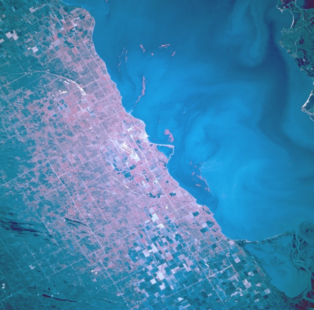 |
| STS068-202-090 Gimli, Manitoba, Canada October 1994 The dual runways (paralleling linear feature) of Gimli Industrial Park Airport are visible slightly left of center and the resort community of Gimli (Rural Municipality) can be identified due east of the airport along the shoreline of Lake Winnipeg in this color infrared image. Gimli was founded by Icelanders and is home to a large fishing fleet. The fleet of over 150 vessels is based in the man-made harbor visible in the center of the photograph. Seagrams Corporation has a one million square foot distilling plant in the industrial park. It is visible to the right of the runways. Notice the definite gridded land use pattern that prevails throughout the entire region. Even the cultivated field patterns (upper left and lower center) are superimposed over the township and homestead survey pattern that is used in the prairie provinces of Canada. This particular scene only shows the extreme southwestern coastline off a much larger Lake Winnipeg. The lighter colored swirls in the water are actually sediment plumes. Part of the marshy delta, found at the southern end of Lake Winnipeg, that has been created by the north flowing Red River is visible in the lower right corner of the picture. |
| Images: | All Available Images Low-Resolution 330k |
|
| Mission: | STS068 |
|
| Roll - Frame: | 202 - 90 |
|
| Geographical Name: | CANADA-M |
|
| Features: | GIMLI, LAKE WINNIPEG, SEDIMENT |
|
| Center Lat x Lon: | 50.5N x 97W |
|
| Film Exposure: | N | N=Normal exposure, U=Under exposed, O=Over exposed, F=out of Focus |
| Percentage of Cloud Cover-CLDP: | 0 |
|
| Camera:: | HB |
|
| Camera Tilt: | 27 | LO=Low Oblique, HO=High Oblique, NV=Near Vertical |
| Camera Focal Length: | 250 |
|
| Nadir to Photo Center Direction: | SW | The direction from the nadir to the center point, N=North, S=South, E=East, W=West |
| Stereo?: | N | Y=Yes there is an adjacent picture of the same area, N=No there isn't |
| Orbit Number: | 70 |
|
| Date: | 19941004 | YYYYMMDD |
| Time: | 174927 | GMT HHMMSS |
| Nadir Lat: | 51.1N |
Latitude of suborbital point of spacecraft |
| Nadir Lon: | 96.2W |
Longitude of suborbital point of spacecraft |
| Sun Azimuth: | 173 | Clockwise angle in degrees from north to the sun measured at the nadir point |
| Space Craft Altitude: | 116 | nautical miles |
| Sun Elevation: | 34 | Angle in degrees between the horizon and the sun, measured at the nadir point |
| Land Views: | PLAIN |
|
| Water Views: | LAKE |
|
| Atmosphere Views: | |
|
| Man Made Views: | AIRPORT, AGRICULTURE |
|
| City Views: | |
|
Photo is not associated with any sequences | ||
| NASA Home Page |
JSC Home Page |
JSC Digital Image Collection |
Earth Science & Remote Sensing |
|
This service is provided by the International Space Station program and the JSC Earth Science & Remote Sensing Unit, ARES Division, Exploration Integration Science Directorate.

|