Geographic Region: INDONESIA-WNG
Feature: NEAR NABIRE
|
Geographic Region: INDONESIA-WNG Feature: NEAR NABIRE |
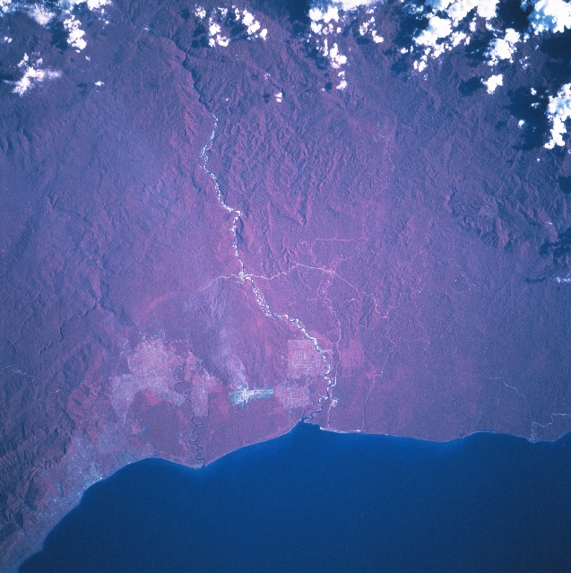 |
| STS068-202-031 Irian Jaya, Indonesia October 1994 The color infrared image (where green vegetation is portrayed as reddish hues) helps to accentuate the dense jungle canopy that covers most of the landscape of Irian Jaya, the easternmost state of Indonesia. Irian Jaya shares the western half of the world's second largest island, New Guinea. The few exceptions to the otherwise uniform-looking tropical rainforest are the pinkish-looking areas near the coast where the rainforests have been replaced by agricultural sites. This particular section of the north coast is located along the southern extension of the Gulf of Cenderawasin. Nabire, a small port city, is visible near the lower left corner of the image. The linear feature with the highly reflective (whitish), intermittent surfaces, extending generally north to south, is the Wanggar River. The river disappears into a deep gorge near the upper edge of the image. Rugged, mountainous terrain can be discriminated in spite of the dense rainforest foliage. The angular feature near the coast and east of the river is an area where development is taking place. A few roads (light-colored lines) are visible as they cut through the forested coastal plain. STS068-202-032 provides overlapping coverage of the area northeast of this scene. |
| Images: | All Available Images Low-Resolution 355k |
|
| Mission: | STS068 |
|
| Roll - Frame: | 202 - 31 |
|
| Geographical Name: | INDONESIA-WNG |
|
| Features: | NEAR NABIRE |
|
| Center Lat x Lon: | 3.5S x 134.5E |
|
| Film Exposure: | N | N=Normal exposure, U=Under exposed, O=Over exposed, F=out of Focus |
| Percentage of Cloud Cover-CLDP: | 10 |
|
| Camera:: | HB |
|
| Camera Tilt: | 22 | LO=Low Oblique, HO=High Oblique, NV=Near Vertical |
| Camera Focal Length: | 250 |
|
| Nadir to Photo Center Direction: | W | The direction from the nadir to the center point, N=North, S=South, E=East, W=West |
| Stereo?: | N | Y=Yes there is an adjacent picture of the same area, N=No there isn't |
| Orbit Number: | 62 |
|
| Date: | 19941004 | YYYYMMDD |
| Time: | 061656 | GMT HHMMSS |
| Nadir Lat: | 3.6S |
Latitude of suborbital point of spacecraft |
| Nadir Lon: | 135.3E |
Longitude of suborbital point of spacecraft |
| Sun Azimuth: | 267 | Clockwise angle in degrees from north to the sun measured at the nadir point |
| Space Craft Altitude: | 118 | nautical miles |
| Sun Elevation: | 38 | Angle in degrees between the horizon and the sun, measured at the nadir point |
| Land Views: | FOREST |
|
| Water Views: | RIVER |
|
| Atmosphere Views: | |
|
| Man Made Views: | |
|
| City Views: | |
|
Photo is not associated with any sequences | ||
| NASA Home Page |
JSC Home Page |
JSC Digital Image Collection |
Earth Science & Remote Sensing |
|
This service is provided by the International Space Station program and the JSC Earth Science & Remote Sensing Unit, ARES Division, Exploration Integration Science Directorate.

|