
Geographic Region: USA-LOUISIANA
Feature: NEW IBERIA, MORGAN CITY
|
Geographic Region: USA-LOUISIANA Feature: NEW IBERIA, MORGAN CITY |
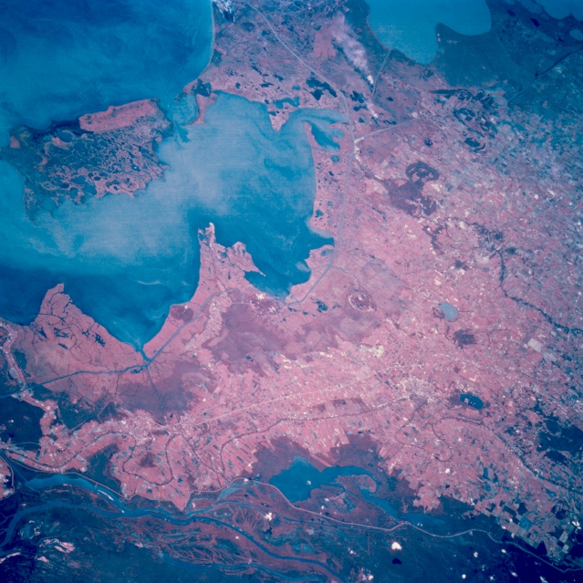 |
| STS068-202-114 New Iberia, Louisiana, U.S.A. October 1994 Brighter, lighter cultivated field patterns differentiate the slightly elevated land from the coastal swamp land in this color infrared photograph. The deeper reds designate dense vegetation (mainly forests) in this part of the Atchafalaya drainage basin. U.S. Highway 90 crosses the elevated terrain, and several tributaries of the Atchafalaya River and its canals, including a small section of the Intracoastal Waterway, appear as darker features at various locations. Vermilion Bay and West Cote Blanche Bay lie north of March Island (upper left corner). Two white smoke plumes are visible south of the Intracoastal Waterway between Vermilion Bay and White Lake to its west (near the top center of the photograph). |
| Images: | All Available Images Low-Resolution 371k |
|
| Mission: | STS068 |
|
| Roll - Frame: | 202 - 114 |
|
| Geographical Name: | USA-LOUISIANA |
|
| Features: | NEW IBERIA, MORGAN CITY |
|
| Center Lat x Lon: | 29.5N x 91.5W |
|
| Film Exposure: | N | N=Normal exposure, U=Under exposed, O=Over exposed, F=out of Focus |
| Percentage of Cloud Cover-CLDP: | 0 |
|
| Camera:: | HB |
|
| Camera Tilt: | 47 | LO=Low Oblique, HO=High Oblique, NV=Near Vertical |
| Camera Focal Length: | 250 |
|
| Nadir to Photo Center Direction: | W | The direction from the nadir to the center point, N=North, S=South, E=East, W=West |
| Stereo?: | N | Y=Yes there is an adjacent picture of the same area, N=No there isn't |
| Orbit Number: | 71 |
|
| Date: | 19941004 | YYYYMMDD |
| Time: | 192557 | GMT HHMMSS |
| Nadir Lat: | 30.1N |
Latitude of suborbital point of spacecraft |
| Nadir Lon: | 89.5W |
Longitude of suborbital point of spacecraft |
| Sun Azimuth: | 219 | Clockwise angle in degrees from north to the sun measured at the nadir point |
| Space Craft Altitude: | 117 | nautical miles |
| Sun Elevation: | 48 | Angle in degrees between the horizon and the sun, measured at the nadir point |
| Land Views: | COAST, PLAIN |
|
| Water Views: | BAY, CHANNEL, RIVER |
|
| Atmosphere Views: | SMOKE |
|
| Man Made Views: | AGRICULTURE, HIGHWAY |
|
| City Views: | |
|
Photo is not associated with any sequences | ||
| NASA Home Page |
JSC Home Page |
JSC Digital Image Collection |
Earth Science & Remote Sensing |
|
This service is provided by the International Space Station program and the JSC Earth Science & Remote Sensing Unit, ARES Division, Exploration Integration Science Directorate.

|