
Geographic Region: USA-PENNSYLVANIA
Feature: SUSQHEHANNA RIVER
|
Geographic Region: USA-PENNSYLVANIA Feature: SUSQHEHANNA RIVER |
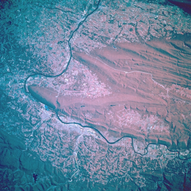 |
| STS068-201-074 Williamsport Area, Pennsylvania October 1994 The Susquehanna River makes a 90-degree turn to the south just to the east of Williamsport, world famous for it's annual Little League Baseball World Series. Williamsport can be identified as the lighter colored area where US Highway 15 is visible as a thin, white line at the bottom of this color infrared image. Bald Eagle Mountain and North White Deer Ridge are the two main northeast-southwest trending mountain ridges south of Williamsport. A small section of Interstate Highway 80, an east-west corridor that crosses the entire state, can be identified as the long, thin white line that extends through one of the many valleys of the Appalachian Mountains (right of center). The darker, uniform terrain (lower left corner) is Tiadaghton State Forest. The densely wooded area south of Williamsport is considered to be part of the Bald Eagle State Forest (deep red). A large segment of the flatter landscape is used for agricultural purposes. |
| Images: | All Available Images Low-Resolution 395k |
|
| Mission: | STS068 |
|
| Roll - Frame: | 201 - 74 |
|
| Geographical Name: | USA-PENNSYLVANIA |
|
| Features: | SUSQHEHANNA RIVER |
|
| Center Lat x Lon: | 41.0N x 77W |
|
| Film Exposure: | N | N=Normal exposure, U=Under exposed, O=Over exposed, F=out of Focus |
| Percentage of Cloud Cover-CLDP: | 0 |
|
| Camera:: | HB |
|
| Camera Tilt: | 15 | LO=Low Oblique, HO=High Oblique, NV=Near Vertical |
| Camera Focal Length: | 250 |
|
| Nadir to Photo Center Direction: | E | The direction from the nadir to the center point, N=North, S=South, E=East, W=West |
| Stereo?: | N | Y=Yes there is an adjacent picture of the same area, N=No there isn't |
| Orbit Number: | 54 |
|
| Date: | 19941003 | YYYYMMDD |
| Time: | 181244 | GMT HHMMSS |
| Nadir Lat: | 41.2N |
Latitude of suborbital point of spacecraft |
| Nadir Lon: | 77.5W |
Longitude of suborbital point of spacecraft |
| Sun Azimuth: | 205 | Clockwise angle in degrees from north to the sun measured at the nadir point |
| Space Craft Altitude: | 117 | nautical miles |
| Sun Elevation: | 42 | Angle in degrees between the horizon and the sun, measured at the nadir point |
| Land Views: | MOUNTAIN, VALLEY, FOREST |
|
| Water Views: | RIVER |
|
| Atmosphere Views: | |
|
| Man Made Views: | HIGHWAY, AGRICULTURE |
|
| City Views: | |
|
Photo is not associated with any sequences | ||
| NASA Home Page |
JSC Home Page |
JSC Digital Image Collection |
Earth Science & Remote Sensing |
|
This service is provided by the International Space Station program and the JSC Earth Science & Remote Sensing Unit, ARES Division, Exploration Integration Science Directorate.

|