
Geographic Region: USA-LOUISIANA
Feature: L. CHARLES, GRAND LAKE
|
Geographic Region: USA-LOUISIANA Feature: L. CHARLES, GRAND LAKE |
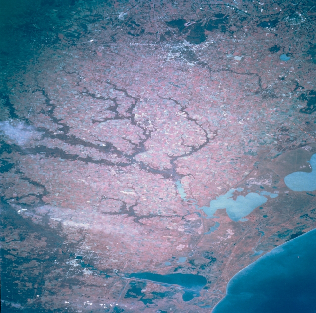 |
| STS068-201-122 Southwest Louisiana, U.S.A. October 1994 Two different landscapes are identifiable in this color infrared photograph of southwest Louisiana--the narrow band of coastal wetlands known as the Chenier Plain and the slightly more elevated, undulating, drier Prairie Complex. The coastal wetlands appear as a complicated pattern of reds (vegetation) with three large lakes (Calcasieu, Grand, and White from west to east) and different shades of blue (water surfaces) that follow the marshy coastline. Even in the wetland environment some elevated sand ridges contain stands of live oak trees. North of the Chenier Plain, the terrain changes to the drier Prairie Complex. Appearing as a large, dark, tentacle-shaped feature (center of photograph) are the forested tributaries of Bayou Nezpique, which eventually empties into the northwest corner of Grand Lake. Barely discernible is Interstate Highway 10 between Lake Charles (bottom left) and Lafayette (upper center). A few wispy smoke plumes appear near the left edge of the photograph. |
| Images: | All Available Images Low-Resolution 368k |
|
| Mission: | STS068 |
|
| Roll - Frame: | 201 - 122 |
|
| Geographical Name: | USA-LOUISIANA |
|
| Features: | L. CHARLES, GRAND LAKE |
|
| Center Lat x Lon: | 30.0N x 93W |
|
| Film Exposure: | N | N=Normal exposure, U=Under exposed, O=Over exposed, F=out of Focus |
| Percentage of Cloud Cover-CLDP: | 0 |
|
| Camera:: | HB |
|
| Camera Tilt: | LO | LO=Low Oblique, HO=High Oblique, NV=Near Vertical |
| Camera Focal Length: | 250 |
|
| Nadir to Photo Center Direction: | W | The direction from the nadir to the center point, N=North, S=South, E=East, W=West |
| Stereo?: | N | Y=Yes there is an adjacent picture of the same area, N=No there isn't |
| Orbit Number: | 55 |
|
| Date: | 19941003 | YYYYMMDD |
| Time: | 194501 | GMT HHMMSS |
| Nadir Lat: | 30.8N |
Latitude of suborbital point of spacecraft |
| Nadir Lon: | 89.1W |
Longitude of suborbital point of spacecraft |
| Sun Azimuth: | 225 | Clockwise angle in degrees from north to the sun measured at the nadir point |
| Space Craft Altitude: | 118 | nautical miles |
| Sun Elevation: | 45 | Angle in degrees between the horizon and the sun, measured at the nadir point |
| Land Views: | COAST, PLAIN |
|
| Water Views: | LAKE |
|
| Atmosphere Views: | SMOKE |
|
| Man Made Views: | |
|
| City Views: | |
|
Photo is not associated with any sequences | ||
| NASA Home Page |
JSC Home Page |
JSC Digital Image Collection |
Earth Science & Remote Sensing |
|
This service is provided by the International Space Station program and the JSC Earth Science & Remote Sensing Unit, ARES Division, Exploration Integration Science Directorate.

|