
Geographic Region: CANADA-O
Feature: THUNDER BAY, PORT ARTHUR
|
Geographic Region: CANADA-O Feature: THUNDER BAY, PORT ARTHUR |
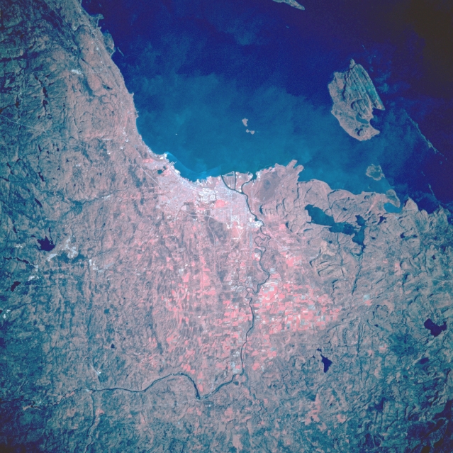 |
| STS068-200-059 Thunder Bay, Ontario, Canada October 1994 Located on the northwest shore of Lake Superior the color infrared image captures the overall physical setting of Thunder Bay, a dynamic industrial and transportation hub for this region of Canada. The general outline of the urban, built-up area is discernible on the picture. The thin, linear feature that skirts along the west side of the city is the Thunder Bay Expressway (also known as Highways 11 and 17). The two intersecting runways of Thunder Bay International Airport are faintly visible along the southwest side of the urban area. The meandering, thin dark line that makes a 90 degree turn to the east is the Kaministiquia River. Notice that the color infrared image helps to accentuate and map the numerous cultivated (red) field patterns (actually showing the location and distribution of healthy green vegetation) west of the city. The dark, irregular shaped features are lakes. The larger island southwest of Thunder Bay is Pie Island. |
| Images: | All Available Images Low-Resolution 374k |
|
| Mission: | STS068 |
|
| Roll - Frame: | 200 - 59 |
|
| Geographical Name: | CANADA-O |
|
| Features: | THUNDER BAY, PORT ARTHUR |
|
| Center Lat x Lon: | 48.5N x 89.5W |
|
| Film Exposure: | N | N=Normal exposure, U=Under exposed, O=Over exposed, F=out of Focus |
| Percentage of Cloud Cover-CLDP: | 0 |
|
| Camera:: | HB |
|
| Camera Tilt: | 40 | LO=Low Oblique, HO=High Oblique, NV=Near Vertical |
| Camera Focal Length: | 250 |
|
| Nadir to Photo Center Direction: | W | The direction from the nadir to the center point, N=North, S=South, E=East, W=West |
| Stereo?: | N | Y=Yes there is an adjacent picture of the same area, N=No there isn't |
| Orbit Number: | 22 |
|
| Date: | 19941001 | YYYYMMDD |
| Time: | 184721 | GMT HHMMSS |
| Nadir Lat: | 48.9N |
Latitude of suborbital point of spacecraft |
| Nadir Lon: | 87.9W |
Longitude of suborbital point of spacecraft |
| Sun Azimuth: | 201 | Clockwise angle in degrees from north to the sun measured at the nadir point |
| Space Craft Altitude: | 118 | nautical miles |
| Sun Elevation: | 36 | Angle in degrees between the horizon and the sun, measured at the nadir point |
| Land Views: | ISLAND, COAST |
|
| Water Views: | LAKE, RIVER |
|
| Atmosphere Views: | |
|
| Man Made Views: | URBAN AREA, AGRICULTURE, HIGHWAY, AIRPORT |
|
| City Views: | |
|
Photo is not associated with any sequences | ||
| NASA Home Page |
JSC Home Page |
JSC Digital Image Collection |
Earth Science & Remote Sensing |
|
This service is provided by the International Space Station program and the JSC Earth Science & Remote Sensing Unit, ARES Division, Exploration Integration Science Directorate.

|