Geographic Region: JAPAN
Feature: COAST NEAR KUSHIRO
|
Geographic Region: JAPAN Feature: COAST NEAR KUSHIRO |
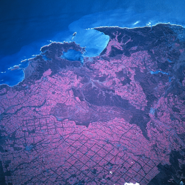 |
| STS068-200-023 Agriculture, Eastern Hokkaido, Japan October 1994 Located at the eastern end of Japan's northernmost large island, Hokkaido, color infrared film (reddish hues represent a variety of green vegetation) helps to delineate a unique, gridded pattern on the landscape. The thin-looking, linear, intersecting pattern appears to be part of an extensive irrigation system that is being used to improve agricultural productivity in the region. In spite of a short growing season (varying from 130 to 150 days) the eastern end of Hokkaido does enjoy a vigorous livestock and dairy farming economy. The large, dark areas are forested terrain (found mainly in hilly or low-lying, swampy areas). There are also a few river valleys visible as the streams flow generally towards the southeast coast of Hokkaido. The locations of two rural cities, Nakashibetsu (lower left) and Shibecha (right middle), can be identified as small, gray-looking areas. Akkeshi Bay is the large bay slightly above the center of the image. The lighter blue waters along the coast and in the bay are actually brownish-looking sediment plumes. The same sediment coloration (lighter blue) is also visible in the small lakes, located northeast of the seaport city of Kushiro (upper right). Refer to STS68-205-064 for overlapping color infrared coverage of the same general area of Hokkaido. |
| Images: | All Available Images Low-Resolution 393k |
|
| Mission: | STS068 |
|
| Roll - Frame: | 200 - 23 |
|
| Geographical Name: | JAPAN |
|
| Features: | COAST NEAR KUSHIRO |
|
| Center Lat x Lon: | 43.0N x 144.5E |
|
| Film Exposure: | N | N=Normal exposure, U=Under exposed, O=Over exposed, F=out of Focus |
| Percentage of Cloud Cover-CLDP: | 0 |
|
| Camera:: | HB |
|
| Camera Tilt: | 44 | LO=Low Oblique, HO=High Oblique, NV=Near Vertical |
| Camera Focal Length: | 250 |
|
| Nadir to Photo Center Direction: | S | The direction from the nadir to the center point, N=North, S=South, E=East, W=West |
| Stereo?: | Y | Y=Yes there is an adjacent picture of the same area, N=No there isn't |
| Orbit Number: | 12 |
|
| Date: | 19941001 | YYYYMMDD |
| Time: | 040031 | GMT HHMMSS |
| Nadir Lat: | 44.8N |
Latitude of suborbital point of spacecraft |
| Nadir Lon: | 145.2E |
Longitude of suborbital point of spacecraft |
| Sun Azimuth: | 215 | Clockwise angle in degrees from north to the sun measured at the nadir point |
| Space Craft Altitude: | 118 | nautical miles |
| Sun Elevation: | 36 | Angle in degrees between the horizon and the sun, measured at the nadir point |
| Land Views: | COAST, PLAIN |
|
| Water Views: | RIVER, LAKE, BAY |
|
| Atmosphere Views: | |
|
| Man Made Views: | DEFORESTATION |
|
| City Views: | |
|
Photo is not associated with any sequences | ||
| NASA Home Page |
JSC Home Page |
JSC Digital Image Collection |
Earth Science & Remote Sensing |
|
This service is provided by the International Space Station program and the JSC Earth Science & Remote Sensing Unit, ARES Division, Exploration Integration Science Directorate.

|