Geographic Region: RUSSIAN FEDERATION
Feature: TOBOL RIVER VALLEY
|
Geographic Region: RUSSIAN FEDERATION Feature: TOBOL RIVER VALLEY |
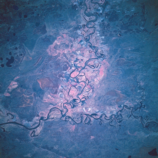 |
| STS068-200-105 Tobol River, Russia October 1994 Described by many scientists as the world's largest unbroken lowland, the West Siberian Plain is a region of numerous river basins and broad expanses of swampy terrain. The Tobol River flows northeasterly until it merges with the easterly draining Tavda River and then the Tobol takes an easterly course. Notice that both rivers have very dramatic meandering stream channels. In particular the Tobol River has an assortment of meander scars and several oxbow lakes that have formed in the wide floodplain of this constantly changing river. East of the confluence of these two rivers (lower left quadrant) the Tobol River becomes a winding stream. The nature of the color infrared image with the pinkish-looking areas (representing green vegetation) scattered throughout the scene shows areas where vegetative cover can be mapped. |
| Images: | All Available Images Low-Resolution 394k |
|
| Mission: | STS068 |
|
| Roll - Frame: | 200 - 105 |
|
| Geographical Name: | RUSSIAN FEDERATION |
|
| Features: | TOBOL RIVER VALLEY |
|
| Center Lat x Lon: | 57.0N x 67.0E |
|
| Film Exposure: | N | N=Normal exposure, U=Under exposed, O=Over exposed, F=out of Focus |
| Percentage of Cloud Cover-CLDP: | 0 |
|
| Camera:: | HB |
|
| Camera Tilt: | 14 | LO=Low Oblique, HO=High Oblique, NV=Near Vertical |
| Camera Focal Length: | 250 |
|
| Nadir to Photo Center Direction: | W | The direction from the nadir to the center point, N=North, S=South, E=East, W=West |
| Stereo?: | Y | Y=Yes there is an adjacent picture of the same area, N=No there isn't |
| Orbit Number: | 29 |
|
| Date: | 19941002 | YYYYMMDD |
| Time: | 050152 | GMT HHMMSS |
| Nadir Lat: | 57.0N |
Latitude of suborbital point of spacecraft |
| Nadir Lon: | 67.5E |
Longitude of suborbital point of spacecraft |
| Sun Azimuth: | 142 | Clockwise angle in degrees from north to the sun measured at the nadir point |
| Space Craft Altitude: | 117 | nautical miles |
| Sun Elevation: | 24 | Angle in degrees between the horizon and the sun, measured at the nadir point |
| Land Views: | FLOOD PLAIN |
|
| Water Views: | RIVER |
|
| Atmosphere Views: | |
|
| Man Made Views: | |
|
| City Views: | |
|
Photo is not associated with any sequences | ||
| NASA Home Page |
JSC Home Page |
JSC Digital Image Collection |
Earth Science & Remote Sensing |
|
This service is provided by the International Space Station program and the JSC Earth Science & Remote Sensing Unit, ARES Division, Exploration Integration Science Directorate.

|