
Geographic Region: USA-TEXAS
Feature: TYLER, KILGORE, LONGVIEW
|
Geographic Region: USA-TEXAS Feature: TYLER, KILGORE, LONGVIEW |
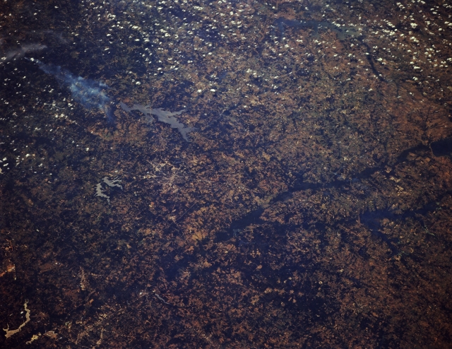 |
| STS068-174-171 Sabine River, Northeast Texas, U.S.A. October 1994 Featured beneath cumulus clouds are Cedar Creek Lake (upper right edge), a tributary of the Trinity River basin, in this forested region of northeast Texas and the dark wooded river bottom of the Sabine River into which feeds Lake Fork Reservoir. Elongated Lake Palestine (center of photograph) and a wispy smoke plume to its south are visible. A pattern of intersecting highways helps to locate Tyler, northeast of Lake Palestine. Southeast of Tyler are two small, irregular reservoirs--more westerly Lake Tyler and smaller Lake Tyler East. Apparent are some of the highway network within Longview northeast of Tyler (lower left corner) and lighter lakes southeast of Longview. |
| Images: | All Available Images Low-Resolution 315k |
|
| Mission: | STS068 |
|
| Roll - Frame: | 174 - 171 |
|
| Geographical Name: | USA-TEXAS |
|
| Features: | TYLER, KILGORE, LONGVIEW |
|
| Center Lat x Lon: | 32.5N x 95.5W |
|
| Film Exposure: | N | N=Normal exposure, U=Under exposed, O=Over exposed, F=out of Focus |
| Percentage of Cloud Cover-CLDP: | 5 |
|
| Camera:: | LH |
|
| Camera Tilt: | 45 | LO=Low Oblique, HO=High Oblique, NV=Near Vertical |
| Camera Focal Length: | 250 |
|
| Nadir to Photo Center Direction: | W | The direction from the nadir to the center point, N=North, S=South, E=East, W=West |
| Stereo?: | Y | Y=Yes there is an adjacent picture of the same area, N=No there isn't |
| Orbit Number: | 103 |
|
| Date: | 19941006 | YYYYMMDD |
| Time: | 184513 | GMT HHMMSS |
| Nadir Lat: | 33.1N |
Latitude of suborbital point of spacecraft |
| Nadir Lon: | 93.7W |
Longitude of suborbital point of spacecraft |
| Sun Azimuth: | 197 | Clockwise angle in degrees from north to the sun measured at the nadir point |
| Space Craft Altitude: | 116 | nautical miles |
| Sun Elevation: | 51 | Angle in degrees between the horizon and the sun, measured at the nadir point |
| Land Views: | RANGE, HILL |
|
| Water Views: | RESERVOIR |
|
| Atmosphere Views: | SMOKE |
|
| Man Made Views: | |
|
| City Views: | |
|
Photo is not associated with any sequences | ||
| NASA Home Page |
JSC Home Page |
JSC Digital Image Collection |
Earth Science & Remote Sensing |
|
This service is provided by the International Space Station program and the JSC Earth Science & Remote Sensing Unit, ARES Division, Exploration Integration Science Directorate.

|