
Geographic Region: USA-WASHINGTON
Feature: COLUMBIA R, MOSES LAKE
|
Geographic Region: USA-WASHINGTON Feature: COLUMBIA R, MOSES LAKE |
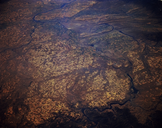 |
| STS068-174-151 Columbia Plateau and Columbia River, Washington U.S.A. October 1994 The scablands (eroded basalt surfaces) and agricultural areas of the Columbia Plateau are visible in this southwest-looking, low-oblique photograph. Because of its rivers and lakes, the Columbia Plateau is an important source of hydroelectric power for Washington. The Spokane River can be seen joining the Columbia River at the bottom center of the photograph, and the confluence of the Snake River and Columbia River is evident just left of the photograph's center, near Kinnewick, Washington. Near the bottom right appears Grand Coulee Dam; directly to its south is Banks Lake, which sits in a canyon (coulee) that was the course of the Columbia River during the ice age. |
| Images: | All Available Images Low-Resolution 297k |
|
| Mission: | STS068 |
|
| Roll - Frame: | 174 - 151 |
|
| Geographical Name: | USA-WASHINGTON |
|
| Features: | COLUMBIA R, MOSES LAKE |
|
| Center Lat x Lon: | 47.0N x 119W |
|
| Film Exposure: | N | N=Normal exposure, U=Under exposed, O=Over exposed, F=out of Focus |
| Percentage of Cloud Cover-CLDP: | 0 |
|
| Camera:: | LH |
|
| Camera Tilt: | LO | LO=Low Oblique, HO=High Oblique, NV=Near Vertical |
| Camera Focal Length: | 250 |
|
| Nadir to Photo Center Direction: | SW | The direction from the nadir to the center point, N=North, S=South, E=East, W=West |
| Stereo?: | Y | Y=Yes there is an adjacent picture of the same area, N=No there isn't |
| Orbit Number: | 103 |
|
| Date: | 19941006 | YYYYMMDD |
| Time: | 183916 | GMT HHMMSS |
| Nadir Lat: | 49.4N |
Latitude of suborbital point of spacecraft |
| Nadir Lon: | 116.2W |
Longitude of suborbital point of spacecraft |
| Sun Azimuth: | 164 | Clockwise angle in degrees from north to the sun measured at the nadir point |
| Space Craft Altitude: | 115 | nautical miles |
| Sun Elevation: | 34 | Angle in degrees between the horizon and the sun, measured at the nadir point |
| Land Views: | PLATEAU |
|
| Water Views: | RIVER, RESERVOIR |
|
| Atmosphere Views: | |
|
| Man Made Views: | AGRICULTURE |
|
| City Views: | |
|
Photo is not associated with any sequences | ||
| NASA Home Page |
JSC Home Page |
JSC Digital Image Collection |
Earth Science & Remote Sensing |
|
This service is provided by the International Space Station program and the JSC Earth Science & Remote Sensing Unit, ARES Division, Exploration Integration Science Directorate.

|