
Geographic Region: USA-WASHINGTON
Feature: COLUMBIA R, AGR. PATTERNS
|
Geographic Region: USA-WASHINGTON Feature: COLUMBIA R, AGR. PATTERNS |
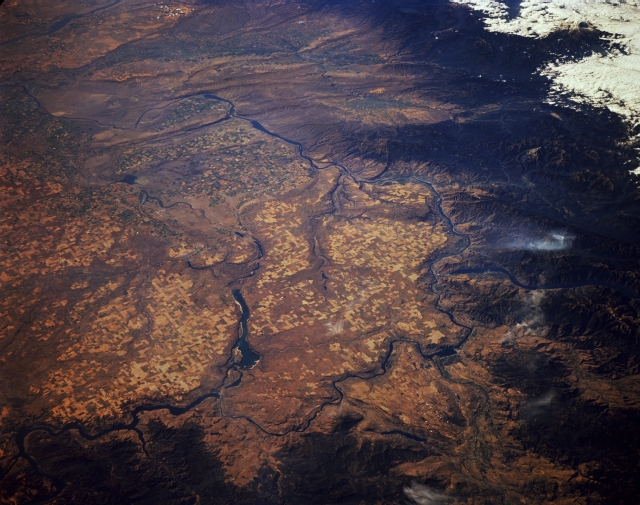 |
| STS068-174-150 Columbia River and Columbia Plateau, Washington, U.S.A. October 1994 Agricultural field patterns and the Columbia River are featured in this south-southwest-looking, low-oblique photograph of the vast Columbia Plateau. An important agricultural and grazing region, the plateau is underlaid by deposits of lava (mainly basalt) some 10 000 feet (3050 meters) thick interbedded with sedimentary rock and overlaid with volcanic ash. The Washington area of the plateau has scattered coulees (dry river canyons) and scablands (extensively eroded basalt surfaces) that were carved by glacial meltwaters. The Columbia River twists westward to the base of the Cascade Range and turns south. Grand Coulee Dam is barely discernible midway between the lower left and lower center of the photograph. Just south of Grand Coulee Dam is Banks Lake, which was part of the Columbia River channel during the ice age. Near the right center, Lake Chelan, the third deepest freshwater lake in the United States, is visible. Other lakes and dams dot the course of the Columbia River, making the plateau an important source of hydroelectric power. |
| Images: | All Available Images Low-Resolution 296k |
|
| Mission: | STS068 |
|
| Roll - Frame: | 174 - 150 |
|
| Geographical Name: | USA-WASHINGTON |
|
| Features: | COLUMBIA R, AGR. PATTERNS |
|
| Center Lat x Lon: | 47.5N x 119.5W |
|
| Film Exposure: | N | N=Normal exposure, U=Under exposed, O=Over exposed, F=out of Focus |
| Percentage of Cloud Cover-CLDP: | 5 |
|
| Camera:: | LH |
|
| Camera Tilt: | LO | LO=Low Oblique, HO=High Oblique, NV=Near Vertical |
| Camera Focal Length: | 250 |
|
| Nadir to Photo Center Direction: | SW | The direction from the nadir to the center point, N=North, S=South, E=East, W=West |
| Stereo?: | Y | Y=Yes there is an adjacent picture of the same area, N=No there isn't |
| Orbit Number: | 103 |
|
| Date: | 19941006 | YYYYMMDD |
| Time: | 183906 | GMT HHMMSS |
| Nadir Lat: | 49.8N |
Latitude of suborbital point of spacecraft |
| Nadir Lon: | 117.1W |
Longitude of suborbital point of spacecraft |
| Sun Azimuth: | 163 | Clockwise angle in degrees from north to the sun measured at the nadir point |
| Space Craft Altitude: | 115 | nautical miles |
| Sun Elevation: | 34 | Angle in degrees between the horizon and the sun, measured at the nadir point |
| Land Views: | PLATEAU |
|
| Water Views: | RIVER, RESERVOIR |
|
| Atmosphere Views: | |
|
| Man Made Views: | AGRICULTURE |
|
| City Views: | |
|
Photo is not associated with any sequences | ||
| NASA Home Page |
JSC Home Page |
JSC Digital Image Collection |
Earth Science & Remote Sensing |
|
This service is provided by the International Space Station program and the JSC Earth Science & Remote Sensing Unit, ARES Division, Exploration Integration Science Directorate.

|