Geographic Region: CANADA-M
Feature: GRAND RAPIDS AREA
|
Geographic Region: CANADA-M Feature: GRAND RAPIDS AREA |
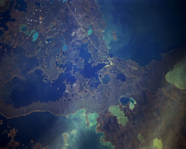 |
| STS068-174-122 Grand Rapids, Manitoba, Canada October 1994 The Saskatchewan River enters the northwest corner of Lake Winnipeg through a small channel slightly right of center at the junction of Provincial Highway 6 and the small village of Grand Rapids. Provincial Highway 60, an east-west roadway, intersects with Highway 6 southeast of Grand Rapids. The three larger bodies of water are Lake Winnipeg (upper right), Lake Winnipegosis (lower left), and Cedar Lake (middle left). Numerous lakes of various colors cover the entire swampy, flat landscape in this region of central Manitoba. |
| Images: | All Available Images Low-Resolution 246k |
|
| Mission: | STS068 |
|
| Roll - Frame: | 174 - 122 |
|
| Geographical Name: | CANADA-M |
|
| Features: | GRAND RAPIDS AREA |
|
| Center Lat x Lon: | 53.0N x 99W |
|
| Film Exposure: | N | N=Normal exposure, U=Under exposed, O=Over exposed, F=out of Focus |
| Percentage of Cloud Cover-CLDP: | 10 |
|
| Camera:: | LH |
|
| Camera Tilt: | NV | LO=Low Oblique, HO=High Oblique, NV=Near Vertical |
| Camera Focal Length: | 250 |
|
| Nadir to Photo Center Direction: | NE | The direction from the nadir to the center point, N=North, S=South, E=East, W=West |
| Stereo?: | Y | Y=Yes there is an adjacent picture of the same area, N=No there isn't |
| Orbit Number: | 102 |
|
| Date: | 19941006 | YYYYMMDD |
| Time: | 170922 | GMT HHMMSS |
| Nadir Lat: | 51.8N |
Latitude of suborbital point of spacecraft |
| Nadir Lon: | 99.7W |
Longitude of suborbital point of spacecraft |
| Sun Azimuth: | 157 | Clockwise angle in degrees from north to the sun measured at the nadir point |
| Space Craft Altitude: | 115 | nautical miles |
| Sun Elevation: | 31 | Angle in degrees between the horizon and the sun, measured at the nadir point |
| Land Views: | |
|
| Water Views: | LAKE, SWAMP |
|
| Atmosphere Views: | |
|
| Man Made Views: | HIGHWAY |
|
| City Views: | |
|
Photo is not associated with any sequences | ||
| NASA Home Page |
JSC Home Page |
JSC Digital Image Collection |
Earth Science & Remote Sensing |
|
This service is provided by the International Space Station program and the JSC Earth Science & Remote Sensing Unit, ARES Division, Exploration Integration Science Directorate.

|