
Geographic Region: USA-NEW JERSEY
Feature: DELAWARE R. & B., CITIES
|
Geographic Region: USA-NEW JERSEY Feature: DELAWARE R. & B., CITIES |
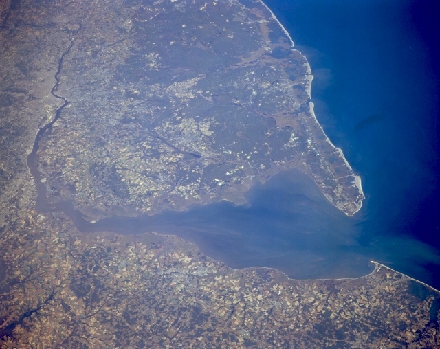 |
| STS068-173-106 Delaware Bay and Southern New Jersey, New Jersey, U.S.A. October 1994 Because of the small scale and low oblique look angle of this northeast view of Delaware Bay and southern New Jersey, none of the infrastructure that is associated with urban development can be identified in this picture that includes Dover and Wilmington Delaware, Philadelphia, Pennsylvania; and Camden and Atlantic City, New Jersey. Notice the almost straight line (northeast-southwest alignment) along the New Jersey coast that separates the barrier island beaches from the elevated, forested lands (dark region) towards the interior. These beaches are continuously subjected to erosion and reshaping. The coastal barrier beach is a classic example of an extensive sandy beach (light colored area) immediately adjacent to the Atlantic Ocean. Heading inland from the beach there is a sequence of sand dunes, elevated barrier flats, lower salt marshes, and finally many lagoons before reaching the elevated forested lands. The Delaware River, which serves as the state boundary between Pennsylvania and New Jersey, can be traced as it flows northeasterly until it reaches Trenton, New Jersey where it makes a 90 degree turn to the northwest. |
| Images: | All Available Images Low-Resolution 279k |
|
| Mission: | STS068 |
|
| Roll - Frame: | 173 - 106 |
|
| Geographical Name: | USA-NEW JERSEY |
|
| Features: | DELAWARE R. & B., CITIES |
|
| Center Lat x Lon: | 39.5N x 75.5W |
|
| Film Exposure: | N | N=Normal exposure, U=Under exposed, O=Over exposed, F=out of Focus |
| Percentage of Cloud Cover-CLDP: | 0 |
|
| Camera:: | LH |
|
| Camera Tilt: | 47 | LO=Low Oblique, HO=High Oblique, NV=Near Vertical |
| Camera Focal Length: | 250 |
|
| Nadir to Photo Center Direction: | NE | The direction from the nadir to the center point, N=North, S=South, E=East, W=West |
| Stereo?: | Y | Y=Yes there is an adjacent picture of the same area, N=No there isn't |
| Orbit Number: | 118 |
|
| Date: | 19941007 | YYYYMMDD |
| Time: | 165424 | GMT HHMMSS |
| Nadir Lat: | 37.8N |
Latitude of suborbital point of spacecraft |
| Nadir Lon: | 76.5W |
Longitude of suborbital point of spacecraft |
| Sun Azimuth: | 180 | Clockwise angle in degrees from north to the sun measured at the nadir point |
| Space Craft Altitude: | 111 | nautical miles |
| Sun Elevation: | 47 | Angle in degrees between the horizon and the sun, measured at the nadir point |
| Land Views: | COAST, PENINSULA |
|
| Water Views: | BAY, LAGOON, RIVER |
|
| Atmosphere Views: | |
|
| Man Made Views: | |
|
| City Views: | |
|
Photo is not associated with any sequences | ||
| NASA Home Page |
JSC Home Page |
JSC Digital Image Collection |
Earth Science & Remote Sensing |
|
This service is provided by the International Space Station program and the JSC Earth Science & Remote Sensing Unit, ARES Division, Exploration Integration Science Directorate.

|