
Geographic Region: USA-PENNSYLVANIA
Feature: APPALACHIAN MTS., RIV,CY
|
Geographic Region: USA-PENNSYLVANIA Feature: APPALACHIAN MTS., RIV,CY |
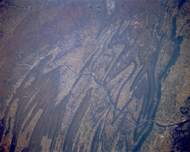 |
| STS068-173-103 Susquehanna River Valley, Pennsylvania October 1994 The Susquehanna River winds it's way through and around several of the prominent ridges in this section of the folded Appalachian Mountains in central Pennsylvania. Harrisburg, the state capital, is located along the east side of the Susquehanna River (lower left corner). Part of the Juniata River is visible as it flows into the Susquehanna River north of the Harrisburg area and paralleling ridges of the Blue Mountains. Even though the mountain ridges and cultivated valley region is very much in evidence in this northeast view of the Susquehanna River Basin, North Mountain (upper left quadrant) presents a different type of mountainous terrain. The lighter colored areas in the valleys show agricultural lands and the darker landscape is predominately forested lands. |
| Images: | All Available Images Low-Resolution 299k |
|
| Mission: | STS068 |
|
| Roll - Frame: | 173 - 103 |
|
| Geographical Name: | USA-PENNSYLVANIA |
|
| Features: | APPALACHIAN MTS., RIV,CY |
|
| Center Lat x Lon: | 41.0N x 77W |
|
| Film Exposure: | N | N=Normal exposure, U=Under exposed, O=Over exposed, F=out of Focus |
| Percentage of Cloud Cover-CLDP: | 0 |
|
| Camera:: | LH |
|
| Camera Tilt: | 48 | LO=Low Oblique, HO=High Oblique, NV=Near Vertical |
| Camera Focal Length: | 250 |
|
| Nadir to Photo Center Direction: | NE | The direction from the nadir to the center point, N=North, S=South, E=East, W=West |
| Stereo?: | Y | Y=Yes there is an adjacent picture of the same area, N=No there isn't |
| Orbit Number: | 118 |
|
| Date: | 19941007 | YYYYMMDD |
| Time: | 165353 | GMT HHMMSS |
| Nadir Lat: | 39.3N |
Latitude of suborbital point of spacecraft |
| Nadir Lon: | 78.2W |
Longitude of suborbital point of spacecraft |
| Sun Azimuth: | 178 | Clockwise angle in degrees from north to the sun measured at the nadir point |
| Space Craft Altitude: | 111 | nautical miles |
| Sun Elevation: | 45 | Angle in degrees between the horizon and the sun, measured at the nadir point |
| Land Views: | MOUNTAIN, VALLEY |
|
| Water Views: | RIVER |
|
| Atmosphere Views: | |
|
| Man Made Views: | AGRICULTURE |
|
| City Views: | |
|
Photo is not associated with any sequences | ||
| NASA Home Page |
JSC Home Page |
JSC Digital Image Collection |
Earth Science & Remote Sensing |
|
This service is provided by the International Space Station program and the JSC Earth Science & Remote Sensing Unit, ARES Division, Exploration Integration Science Directorate.

|