
Geographic Region: USA-LOUISIANA
Feature: GRAND & WHITE L., AGRICULTURE
|
Geographic Region: USA-LOUISIANA Feature: GRAND & WHITE L., AGRICULTURE |
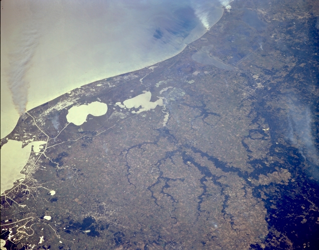 |
| STS068-170-079 Southwest Louisiana, U.S.A. October 1994 Sunglint, the sun's reflection off the water, helps differentiate land-water boundaries in this photograph of the southwest coast of Louisiana. From east to west a large bay and several lakes are identifiable--Vermilion Bay (left edge), White Lake, and Grand Lake. Farther west are elongated Calcasieu Lake and Sabine Lake, which lies on the Texas-Louisiana border. The coastal plains are a mixture of fresh and salt marshes and grasslands; the darker area is the southern extent of a slightly undulating, upland, forested landscape. Several wooded tributaries of Bayou Nezpique present a dendritic drainage pattern as this bayou empties into Grand Lake from the north. Three large smoke plumes are visible along the shoreline, and the white, linear features near the coast are part of the Intracoastal Waterway and interconnecting canals. Lafayette to the east and Lake Charles to the west can be identified by their street patterns. |
| Images: | All Available Images Low-Resolution 278k |
|
| Mission: | STS068 |
|
| Roll - Frame: | 170 - 79 |
|
| Geographical Name: | USA-LOUISIANA |
|
| Features: | GRAND & WHITE L., AGRICULTURE |
|
| Center Lat x Lon: | 30.0N x 92.5W |
|
| Film Exposure: | N | N=Normal exposure, U=Under exposed, O=Over exposed, F=out of Focus |
| Percentage of Cloud Cover-CLDP: | 0 |
|
| Camera:: | LH |
|
| Camera Tilt: | 51 | LO=Low Oblique, HO=High Oblique, NV=Near Vertical |
| Camera Focal Length: | 250 |
|
| Nadir to Photo Center Direction: | W | The direction from the nadir to the center point, N=North, S=South, E=East, W=West |
| Stereo?: | Y | Y=Yes there is an adjacent picture of the same area, N=No there isn't |
| Orbit Number: | 71 |
|
| Date: | 19941004 | YYYYMMDD |
| Time: | 192538 | GMT HHMMSS |
| Nadir Lat: | 31.0N |
Latitude of suborbital point of spacecraft |
| Nadir Lon: | 90.3W |
Longitude of suborbital point of spacecraft |
| Sun Azimuth: | 217 | Clockwise angle in degrees from north to the sun measured at the nadir point |
| Space Craft Altitude: | 117 | nautical miles |
| Sun Elevation: | 48 | Angle in degrees between the horizon and the sun, measured at the nadir point |
| Land Views: | COAST, PLAIN |
|
| Water Views: | LAKE, CHANNEL |
|
| Atmosphere Views: | SMOKE |
|
| Man Made Views: | |
|
| City Views: | |
|
Photo is not associated with any sequences | ||
| NASA Home Page |
JSC Home Page |
JSC Digital Image Collection |
Earth Science & Remote Sensing |
|
This service is provided by the International Space Station program and the JSC Earth Science & Remote Sensing Unit, ARES Division, Exploration Integration Science Directorate.

|