
Geographic Region: USA-MONTANA
Feature: FLATHEAD L., MISSION RA.
|
Geographic Region: USA-MONTANA Feature: FLATHEAD L., MISSION RA. |
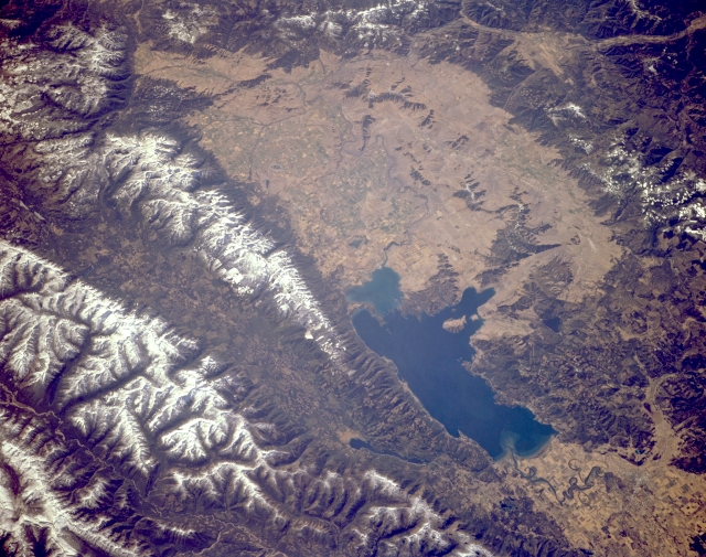 |
| STS068-170-060 Flathead Lake, Mission Range, and Swan Range, Montana, U.S.A. October 1994 Formed by glacial damming of the Flathead River during the last ice age, Flathead Lake [30 miles (48 kilometers) long and 12 to 14 miles (19 to 23 kilometers) wide] and Flathead Valley are featured in this southwest-looking, low-oblique photograph. Barely discernible north of the lake is the small city of Kalispell. To the east of the lake lie two rugged, deeply glaciated, snow-covered mountain ranges separated by an elongated glaciated valley. Also, east of Flathead Lake are the Mission Range and to the north Swan Valley and the Swan Range. Visible are numerous agricultural field patterns south of the lake in Flathead Valley and portions of the Salish Mountains west of the lake. |
| Images: | All Available Images Low-Resolution 318k |
|
| Mission: | STS068 |
|
| Roll - Frame: | 170 - 60 |
|
| Geographical Name: | USA-MONTANA |
|
| Features: | FLATHEAD L., MISSION RA. |
|
| Center Lat x Lon: | 47.5N x 114W |
|
| Film Exposure: | N | N=Normal exposure, U=Under exposed, O=Over exposed, F=out of Focus |
| Percentage of Cloud Cover-CLDP: | 0 |
|
| Camera:: | LH |
|
| Camera Tilt: | 42 | LO=Low Oblique, HO=High Oblique, NV=Near Vertical |
| Camera Focal Length: | 250 |
|
| Nadir to Photo Center Direction: | SW | The direction from the nadir to the center point, N=North, S=South, E=East, W=West |
| Stereo?: | Y | Y=Yes there is an adjacent picture of the same area, N=No there isn't |
| Orbit Number: | 71 |
|
| Date: | 19941004 | YYYYMMDD |
| Time: | 191927 | GMT HHMMSS |
| Nadir Lat: | 48.4N |
Latitude of suborbital point of spacecraft |
| Nadir Lon: | 112.5W |
Longitude of suborbital point of spacecraft |
| Sun Azimuth: | 180 | Clockwise angle in degrees from north to the sun measured at the nadir point |
| Space Craft Altitude: | 116 | nautical miles |
| Sun Elevation: | 37 | Angle in degrees between the horizon and the sun, measured at the nadir point |
| Land Views: | VALLEY, MOUNTAIN, FAULT |
|
| Water Views: | LAKE |
|
| Atmosphere Views: | |
|
| Man Made Views: | AGRICULTURE |
|
| City Views: | |
|
Photo is not associated with any sequences | ||
| NASA Home Page |
JSC Home Page |
JSC Digital Image Collection |
Earth Science & Remote Sensing |
|
This service is provided by the International Space Station program and the JSC Earth Science & Remote Sensing Unit, ARES Division, Exploration Integration Science Directorate.

|