Geographic Region: CANADA-BC
Feature: KAMLOOPS L., FORESTS, R.
|
Geographic Region: CANADA-BC Feature: KAMLOOPS L., FORESTS, R. |
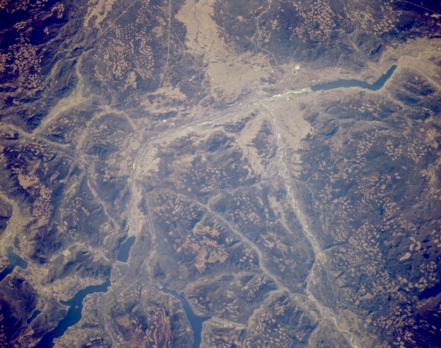 |
| STS068-170-55B Kamloops Area, British Columbia, Canada October 1994 Kamloops, primarily an industrial city in south central British Columbia, is located along the northwest shore of the confluence of the North Thompson and South Thompson Rivers. It is difficult to locate the city because none of the urban infrastructure can be identified on this scale image. Kamloops Lake is the elongated reservoir (dark feature) just west of the city (upper right). As the pock-marked mountainous landscape shows, Kamloops is a major service center for the vast lumbering industry that is active in British Columbia. In addition to the clear cut areas on the mountain slopes, much of the valley in the vicinity of Kamloops shows evidence (lighter, tannish looking areas) of mining operations (mainly gold and copper). The thin, linear, light colored features are powerline right of ways and roads. Adams Lake and Shuswap Lake are the larger reservoirs in the lower left corner of the picture. |
| Images: | All Available Images Low-Resolution 318k |
|
| Mission: | STS068 |
|
| Roll - Frame: | 170 - 55 B |
|
| Geographical Name: | CANADA-BC |
|
| Features: | KAMLOOPS L., FORESTS, R. |
|
| Center Lat x Lon: | 51.0N x 120W |
|
| Film Exposure: | N | N=Normal exposure, U=Under exposed, O=Over exposed, F=out of Focus |
| Percentage of Cloud Cover-CLDP: | 0 |
|
| Camera:: | LH |
|
| Camera Tilt: | 30 | LO=Low Oblique, HO=High Oblique, NV=Near Vertical |
| Camera Focal Length: | 250 |
|
| Nadir to Photo Center Direction: | W | The direction from the nadir to the center point, N=North, S=South, E=East, W=West |
| Stereo?: | Y | Y=Yes there is an adjacent picture of the same area, N=No there isn't |
| Orbit Number: | 71 |
|
| Date: | 19941004 | YYYYMMDD |
| Time: | 191811 | GMT HHMMSS |
| Nadir Lat: | 51.2N |
Latitude of suborbital point of spacecraft |
| Nadir Lon: | 118.9W |
Longitude of suborbital point of spacecraft |
| Sun Azimuth: | 172 | Clockwise angle in degrees from north to the sun measured at the nadir point |
| Space Craft Altitude: | 116 | nautical miles |
| Sun Elevation: | 34 | Angle in degrees between the horizon and the sun, measured at the nadir point |
| Land Views: | VALLEY, MOUNTAIN |
|
| Water Views: | RIVER, LAKE |
|
| Atmosphere Views: | |
|
| Man Made Views: | DEFORESTATION |
|
| City Views: | |
|
Photo is not associated with any sequences | ||
| NASA Home Page |
JSC Home Page |
JSC Digital Image Collection |
Earth Science & Remote Sensing |
|
This service is provided by the International Space Station program and the JSC Earth Science & Remote Sensing Unit, ARES Division, Exploration Integration Science Directorate.

|