
Geographic Region: AUSTRALIA-NSW
Feature: NEWCASTLE,GT. DIVIDING RA
|
Geographic Region: AUSTRALIA-NSW Feature: NEWCASTLE,GT. DIVIDING RA |
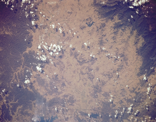 |
| STS068-168-078 New Castle Area, New South Wales, Australia October 1994 Although the scale of this image precludes the identification of specific features, the large dark areas (upper right and bottom right) show forested slopes of mountains (part of the Great Dividing Range) that appear to be volcanic in origin. The pronounced radial drainage pattern that is observed in the lower right corner of the picture seems to support this observation. Although practically none of the actual river channel or floodplain is discernible, the Hunter River Valley runs laterally through the center of the image. The general location of Australia's sixth largest city, Newcastle, is barely visible as a grayish area (left middle edge). This area experienced a 5.6 (Richter Scale) earthquake in December 1989. One reservoir (irregular-shaped, dark feature), Lake Liddell, is visible in the lower right quadrant of the picture. Lake Grahmstown is also visible near the left bottom edge of the image. |
| Images: | All Available Images Low-Resolution 293k |
|
| Mission: | STS068 |
|
| Roll - Frame: | 168 - 78 |
|
| Geographical Name: | AUSTRALIA-NSW |
|
| Features: | NEWCASTLE,GT. DIVIDING RA |
|
| Center Lat x Lon: | 32.5S x 151.5E |
|
| Film Exposure: | N | N=Normal exposure, U=Under exposed, O=Over exposed, F=out of Focus |
| Percentage of Cloud Cover-CLDP: | 10 |
|
| Camera:: | LH |
|
| Camera Tilt: | 21 | LO=Low Oblique, HO=High Oblique, NV=Near Vertical |
| Camera Focal Length: | 250 |
|
| Nadir to Photo Center Direction: | SW | The direction from the nadir to the center point, N=North, S=South, E=East, W=West |
| Stereo?: | Y | Y=Yes there is an adjacent picture of the same area, N=No there isn't |
| Orbit Number: | 142 |
|
| Date: | 19941009 | YYYYMMDD |
| Time: | 044109 | GMT HHMMSS |
| Nadir Lat: | 32S |
Latitude of suborbital point of spacecraft |
| Nadir Lon: | 152.0E |
Longitude of suborbital point of spacecraft |
| Sun Azimuth: | 291 | Clockwise angle in degrees from north to the sun measured at the nadir point |
| Space Craft Altitude: | 111 | nautical miles |
| Sun Elevation: | 41 | Angle in degrees between the horizon and the sun, measured at the nadir point |
| Land Views: | MOUNTAIN |
|
| Water Views: | LAKE |
|
| Atmosphere Views: | |
|
| Man Made Views: | |
|
| City Views: | |
|
Photo is not associated with any sequences | ||
| NASA Home Page |
JSC Home Page |
JSC Digital Image Collection |
Earth Science & Remote Sensing |
|
This service is provided by the International Space Station program and the JSC Earth Science & Remote Sensing Unit, ARES Division, Exploration Integration Science Directorate.

|