Geographic Region: GALAPAGOS ISLANDS
Feature: ISABELLA & FERNANDINA IS
|
Geographic Region: GALAPAGOS ISLANDS Feature: ISABELLA & FERNANDINA IS |
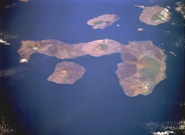 |
| STS068-168-28 Galapagos Islands, Pacific Ocean October 1994 The Galapagos archipelago is a group of 16 generally rough volcanic islands and numerous islets. This east-northeast-looking, low-oblique photograph shows the islands of Fernandina, Isabela, San Salvador, and Santa Cruz. The islands of the Galapagos rose from the ocean floor as tops of volcanoes about 10 million years ago and have never been connected to the South American mainland 650 miles (1045 kilometers) to the east. Isabela Island (seahorse-shaped) has five major volcanic peaks ranging to 5540 feet (1690 meters) in height. Several volcanoes on the islands have been active during the 20th century. The total land area of all the islands, islets, and rocks probably does not exceed 3000 square miles (8000 square kilometers). Isabela Island covers 1700 square miles (4400 square kilometers), more than half of the land area of the archipelago. Though the climate of the islands can vary, the Peru (Humboldt) Current makes the climate mild and dry with temperatures seldom rising above 80 degrees Fahrenheit (27 degrees Celsius) despite the equatorial location. The Galapagos Islands were discovered in 1555 and named for the gigantic land tortoises found there. The islands--famous for their unique vegetation and wildlife--are a wildlife sanctuary. The islands were visited in 1835 by Charles Darwin who gathered data that he used later to support his theory of natural selection. |
| Images: | All Available Images Low-Resolution 58k |
|
| Mission: | STS068 |
|
| Roll - Frame: | 168 - 28 |
|
| Geographical Name: | GALAPAGOS ISLANDS |
|
| Features: | ISABELLA & FERNANDINA IS |
|
| Center Lat x Lon: | 0.5S x 91.5W |
|
| Film Exposure: | N | N=Normal exposure, U=Under exposed, O=Over exposed, F=out of Focus |
| Percentage of Cloud Cover-CLDP: | 5 |
|
| Camera:: | LH |
|
| Camera Tilt: | 50 | LO=Low Oblique, HO=High Oblique, NV=Near Vertical |
| Camera Focal Length: | 250 |
|
| Nadir to Photo Center Direction: | NE | The direction from the nadir to the center point, N=North, S=South, E=East, W=West |
| Stereo?: | Y | Y=Yes there is an adjacent picture of the same area, N=No there isn't |
| Orbit Number: | 136 |
|
| Date: | 19941008 | YYYYMMDD |
| Time: | 194043 | GMT HHMMSS |
| Nadir Lat: | 2S |
Latitude of suborbital point of spacecraft |
| Nadir Lon: | 93.2W |
Longitude of suborbital point of spacecraft |
| Sun Azimuth: | 260 | Clockwise angle in degrees from north to the sun measured at the nadir point |
| Space Craft Altitude: | 112 | nautical miles |
| Sun Elevation: | 65 | Angle in degrees between the horizon and the sun, measured at the nadir point |
| Land Views: | ISLAND, VOLCANO, CRATER, COAST |
|
| Water Views: | OCEAN |
|
| Atmosphere Views: | |
|
| Man Made Views: | |
|
| City Views: | |
|
Photo is not associated with any sequences | ||
| NASA Home Page |
JSC Home Page |
JSC Digital Image Collection |
Earth Science & Remote Sensing |
|
This service is provided by the International Space Station program and the JSC Earth Science & Remote Sensing Unit, ARES Division, Exploration Integration Science Directorate.

|