
Geographic Region: SWITZERLAND
Feature: JURA MTS,L. GENEVA, ALPS
|
Geographic Region: SWITZERLAND Feature: JURA MTS,L. GENEVA, ALPS |
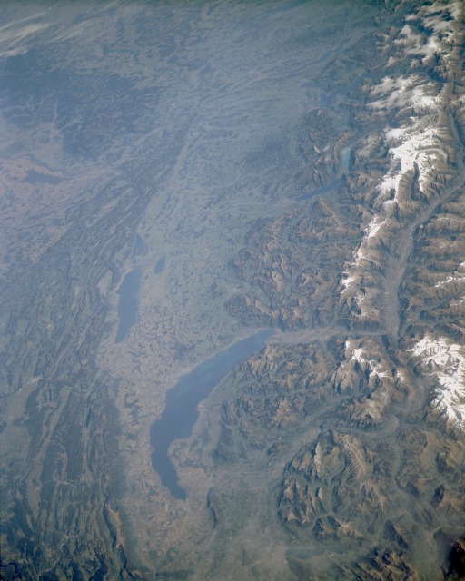 |
| STS068-168-133 Lake Geneva, Bernese Alps, and Jura Mountains, France and Switzerland October 1994 This spectacular, northeast-looking, low-oblique photograph reveals Lake Geneva and the elongated valley between the Jura Mountains of France and the high Bernese Alps of Switzerland. Crescent-shaped Lake Geneva, 45 miles (70 kilometers) long, is noted for its deep-blue, remarkably transparent waters and seiches, tidal fluctuations that suddenly change the lake's water level. The Rhone River enters the lake from the Bernese Alps to the east and exits the lake at its south end through the city of Geneva. North and west of Lake Geneva are the Jura Mountains (visible along the northern edge of the photograph) that extend in northeast-southwest, narrow, parallel ridges. Their rounded crests and summits are covered with pine forests and good pasturelands. Hydroelectric plants scattered throughout the mountains supply power to pulp and paper, textile, watchmaking, and woodworking industries. The Jura Mountains are a popular year-round resort area. East of Lake Geneva are the snow-capped Bernese Alps (visible along the eastern edge of the photograph) that afford some of the finest winter sports and mountaineering terrain in the world. The Bernese Alps, consisting primarily of granite and metamorphic rocks that are extremely resistant to erosion, have an overlay of sedimentary formations that have buckled up and folded. Subsequently scoured by glaciers, the mountains are now marked by deep valleys, knife-edged ridges, and steep walls that rise abruptly from lower slopes. Surrounded by vineyards northeast of Lake Geneva is Neuchatel, an elongated lake 24 miles (39 kilometers) long and 4 to 5 miles (6 to 8 kilometers) wide. |
| Images: | All Available Images Low-Resolution 102k |
|
| Mission: | STS068 |
|
| Roll - Frame: | 168 - 133 |
|
| Geographical Name: | SWITZERLAND |
|
| Features: | JURA MTS,L. GENEVA, ALPS |
|
| Center Lat x Lon: | 46.5N x 7.0E |
|
| Film Exposure: | N | N=Normal exposure, U=Under exposed, O=Over exposed, F=out of Focus |
| Percentage of Cloud Cover-CLDP: | 5 |
|
| Camera:: | LH |
|
| Camera Tilt: | LO | LO=Low Oblique, HO=High Oblique, NV=Near Vertical |
| Camera Focal Length: | 250 |
|
| Nadir to Photo Center Direction: | NE | The direction from the nadir to the center point, N=North, S=South, E=East, W=West |
| Stereo?: | Y | Y=Yes there is an adjacent picture of the same area, N=No there isn't |
| Orbit Number: | 146 |
|
| Date: | 19941009 | YYYYMMDD |
| Time: | 101205 | GMT HHMMSS |
| Nadir Lat: | 44.1N |
Latitude of suborbital point of spacecraft |
| Nadir Lon: | 5.3E |
Longitude of suborbital point of spacecraft |
| Sun Azimuth: | 157 | Clockwise angle in degrees from north to the sun measured at the nadir point |
| Space Craft Altitude: | 110 | nautical miles |
| Sun Elevation: | 37 | Angle in degrees between the horizon and the sun, measured at the nadir point |
| Land Views: | MOUNTAIN, VALLEY, FOREST, FAULT |
|
| Water Views: | LAKE, RIVER |
|
| Atmosphere Views: | |
|
| Man Made Views: | URBAN AREA, AIRPORT |
|
| City Views: | |
|
Photo is not associated with any sequences | ||
| NASA Home Page |
JSC Home Page |
JSC Digital Image Collection |
Earth Science & Remote Sensing |
|
This service is provided by the International Space Station program and the JSC Earth Science & Remote Sensing Unit, ARES Division, Exploration Integration Science Directorate.

|