
Geographic Region: USA-ARKANSAS
Feature: LITTLE ROCK, ARKANSAS RIVER
|
Geographic Region: USA-ARKANSAS Feature: LITTLE ROCK, ARKANSAS RIVER |
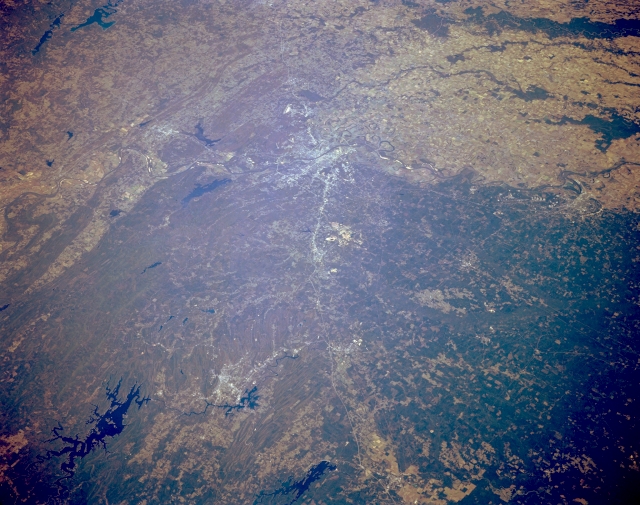 |
| STS068-167-00X Little Rock, Arkansas, U.S.A. October 1994 This synoptic, northeast-looking photograph shows the diverse landscape of central Arkansas. Numerous irregularly shaped, dark reservoirs are identifiable--viewing clockwise from De Gray Lake (bottom center) are Lake Hamilton; serpentine Ouachita Lake; elongated Maumelle Lake; Lake Conway; and part of Greers Ferry Lake. The Arkansas River flows northwest to southeast through the heart of Little Rock (slightly above center), through which runs Interstate Highway 30. The lighter terrain (upper right quadrant) is part of the old Mississippi River floodplain that is used extensively for agriculture. Pine Bluff (near right center) lies southeast of Little Rock. |
| Images: | All Available Images Low-Resolution 304k |
|
| Mission: | STS068 |
|
| Roll - Frame: | 167 - X |
|
| Geographical Name: | USA-ARKANSAS |
|
| Features: | LITTLE ROCK, ARKANSAS RIVER |
|
| Center Lat x Lon: | 34.5N x 93W |
|
| Film Exposure: | N | N=Normal exposure, U=Under exposed, O=Over exposed, F=out of Focus |
| Percentage of Cloud Cover-CLDP: | 0 |
|
| Camera:: | LH |
|
| Camera Tilt: | LO=Low Oblique, HO=High Oblique, NV=Near Vertical |
|
| Camera Focal Length: | 250 |
|
| Nadir to Photo Center Direction: | The direction from the nadir to the center point, N=North, S=South, E=East, W=West |
|
| Stereo?: | Y | Y=Yes there is an adjacent picture of the same area, N=No there isn't |
| Orbit Number: | |
|
| Date: | 1994____ | YYYYMMDD |
| Time: | GMT HHMMSS |
|
| Nadir Lat: | N |
Latitude of suborbital point of spacecraft |
| Nadir Lon: | E |
Longitude of suborbital point of spacecraft |
| Sun Azimuth: | Clockwise angle in degrees from north to the sun measured at the nadir point |
|
| Space Craft Altitude: | nautical miles |
|
| Sun Elevation: | Angle in degrees between the horizon and the sun, measured at the nadir point |
|
| Land Views: | MOUNTAIN, FLOOD PLAIN |
|
| Water Views: | RIVER, LAKE |
|
| Atmosphere Views: | |
|
| Man Made Views: | HIGHWAY, AGRICULTURE |
|
| City Views: | |
|
Photo is not associated with any sequences | ||
| NASA Home Page |
JSC Home Page |
JSC Digital Image Collection |
Earth Science & Remote Sensing |
|
This service is provided by the International Space Station program and the JSC Earth Science & Remote Sensing Unit, ARES Division, Exploration Integration Science Directorate.

|