
Geographic Region: USA-ARKANSAS
Feature: FAYETTEVILLE, RES., RIVER
|
Geographic Region: USA-ARKANSAS Feature: FAYETTEVILLE, RES., RIVER |
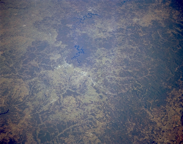 |
| STS068-167-00U Northwest Arkansas, U.S.A. October 1994 Two serpentine lakes, Beaver Lake (closer to center) and Table Rock Lake (near top center) are obvious in the rugged, forested landscape of northwest Arkansas. This synoptic photograph includes Fayetteville, Springdale, and Rogers whose highly reflective urban areas can be identified along north-south-oriented U.S. Highway 71, southeast of which are the generally east-west-trending Boston Mountains. The extensive dark landscape depicts heavily forested terrain. |
| Images: | All Available Images Low-Resolution 291k |
|
| Mission: | STS068 |
|
| Roll - Frame: | 167 - U |
|
| Geographical Name: | USA-ARKANSAS |
|
| Features: | FAYETTEVILLE, RES., RIVER |
|
| Center Lat x Lon: | 36.0N x 94W |
|
| Film Exposure: | N | N=Normal exposure, U=Under exposed, O=Over exposed, F=out of Focus |
| Percentage of Cloud Cover-CLDP: | 0 |
|
| Camera:: | LH |
|
| Camera Tilt: | 50 | LO=Low Oblique, HO=High Oblique, NV=Near Vertical |
| Camera Focal Length: | 250 |
|
| Nadir to Photo Center Direction: | NE | The direction from the nadir to the center point, N=North, S=South, E=East, W=West |
| Stereo?: | Y | Y=Yes there is an adjacent picture of the same area, N=No there isn't |
| Orbit Number: | 151 |
|
| Date: | 19941009 | YYYYMMDD |
| Time: | 173812 | GMT HHMMSS |
| Nadir Lat: | 34.6N |
Latitude of suborbital point of spacecraft |
| Nadir Lon: | 95.7W |
Longitude of suborbital point of spacecraft |
| Sun Azimuth: | 168 | Clockwise angle in degrees from north to the sun measured at the nadir point |
| Space Craft Altitude: | 111 | nautical miles |
| Sun Elevation: | 48 | Angle in degrees between the horizon and the sun, measured at the nadir point |
| Land Views: | MOUNTAIN, FOREST |
|
| Water Views: | LAKE |
|
| Atmosphere Views: | |
|
| Man Made Views: | HIGHWAY |
|
| City Views: | |
|
Photo is not associated with any sequences | ||
| NASA Home Page |
JSC Home Page |
JSC Digital Image Collection |
Earth Science & Remote Sensing |
|
This service is provided by the International Space Station program and the JSC Earth Science & Remote Sensing Unit, ARES Division, Exploration Integration Science Directorate.

|