
Geographic Region: USA-ARKANSAS
Feature: LAKE OF THE CHEROKEE, AGRICULTURE
|
Geographic Region: USA-ARKANSAS Feature: LAKE OF THE CHEROKEE, AGRICULTURE |
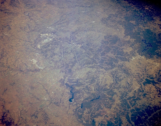 |
| STS068-167-00T Western Ozark Plateau and Joplin, Missouri, U.S.A. October 1994 The four corners of southeast Kansas, southwest Missouri, northwest Arkansas, and northeast Oklahoma are featured in this northeast-looking, panoramic, low-oblique photograph. Low, forested hills cover much of the northwest Ozark Plateau. Viewing clockwise from Springdale and Rogers, Arkansas, and blue, snakelike Beaver Lake (right center) are Tenkiller Ferry Reservoir; dark red Lake Hudson (barely discernible at bottom center); blue Lake of the Cherokees in northeast Oklahoma; at the edge of the Ozarks, Joplin, Missouri (upper left), a shipping and processing point in a grain and livestock region; and Table Rock Lake hovering on the Arkansas-Missouri border (upper right). The large clearing north of Rogers, Arkansas, and northwest of Beaver Lake is Pea Ridge National Military Park, the site of the only major Civil War battle west of the Mississippi River. In March 1862 Union soldiers defeated Confederate soldiers in a fierce 2-day battle, thereby securing Missouri for the Union. |
| Images: | All Available Images Low-Resolution 297k |
|
| Mission: | STS068 |
|
| Roll - Frame: | 167 - T |
|
| Geographical Name: | USA-ARKANSAS |
|
| Features: | LAKE OF THE CHEROKEE, AGRICULTURE |
|
| Center Lat x Lon: | 36.5N x 94.5W |
|
| Film Exposure: | N | N=Normal exposure, U=Under exposed, O=Over exposed, F=out of Focus |
| Percentage of Cloud Cover-CLDP: | 0 |
|
| Camera:: | LH |
|
| Camera Tilt: | 50 | LO=Low Oblique, HO=High Oblique, NV=Near Vertical |
| Camera Focal Length: | 250 |
|
| Nadir to Photo Center Direction: | NE | The direction from the nadir to the center point, N=North, S=South, E=East, W=West |
| Stereo?: | Y | Y=Yes there is an adjacent picture of the same area, N=No there isn't |
| Orbit Number: | 151 |
|
| Date: | 19941009 | YYYYMMDD |
| Time: | 173802 | GMT HHMMSS |
| Nadir Lat: | 35.1N |
Latitude of suborbital point of spacecraft |
| Nadir Lon: | 96.2W |
Longitude of suborbital point of spacecraft |
| Sun Azimuth: | 167 | Clockwise angle in degrees from north to the sun measured at the nadir point |
| Space Craft Altitude: | 111 | nautical miles |
| Sun Elevation: | 48 | Angle in degrees between the horizon and the sun, measured at the nadir point |
| Land Views: | PLATEAU, FOREST |
|
| Water Views: | LAKE |
|
| Atmosphere Views: | |
|
| Man Made Views: | AGRICULTURE |
|
| City Views: | |
|
Photo is not associated with any sequences | ||
| NASA Home Page |
JSC Home Page |
JSC Digital Image Collection |
Earth Science & Remote Sensing |
|
This service is provided by the International Space Station program and the JSC Earth Science & Remote Sensing Unit, ARES Division, Exploration Integration Science Directorate.

|