
Geographic Region: USA-NEBRASKA
Feature: NIOBARA RIVER, SAND HILLS
|
Geographic Region: USA-NEBRASKA Feature: NIOBARA RIVER, SAND HILLS |
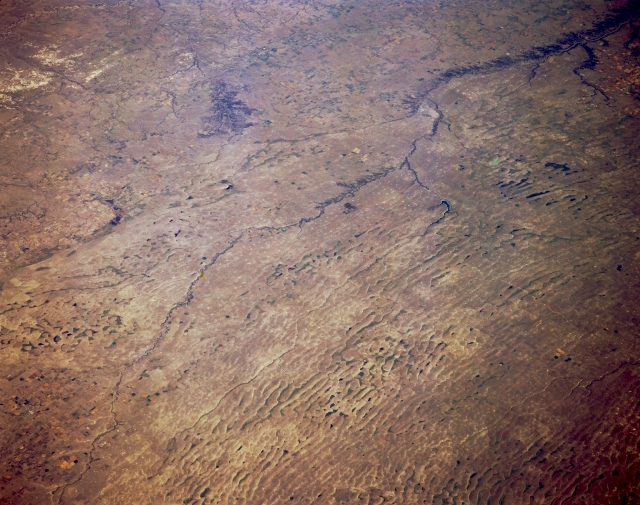 |
| STS068-167-00F Sand Hills and Niobrara River, Nebraska, U.S.A. October 1994 Visible in this northeast-looking, low-oblique photograph is the generally east-flowing Niobrara River of northern Nebraska as it crosses the Sand Hills of north-central Nebraska. The Sand Hills cover 20 000 square miles (50 000 square kilometers) and form the largest sand dune complex in the Western Hemisphere. The dune formation began during the last glacial ice age, with most of the sand apparently coming from alluvial deposits on the floodplains of rivers in the region. South of the Niobrara River, in the westernmost portions of the Sand Hills, large traverse dunes as high as 300 feet (90 meters) and 10 miles (16 kilometers) long have formed. Many of the Sand Hill valleys away from major streams contain wet meadows or small, shallow lakes, many of which rise and fall with the fluctuating water table. A small number of alkali lakes with high concentrations of salt formed a nationally significant source of potash during World War I. Apparent is a small section of the badlands of southern South Dakota (upper left). |
| Images: | All Available Images Low-Resolution 299k |
|
| Mission: | STS068 |
|
| Roll - Frame: | 167 - F |
|
| Geographical Name: | USA-NEBRASKA |
|
| Features: | NIOBARA RIVER, SAND HILLS |
|
| Center Lat x Lon: | 42.5N x 101.5W |
|
| Film Exposure: | N | N=Normal exposure, U=Under exposed, O=Over exposed, F=out of Focus |
| Percentage of Cloud Cover-CLDP: | 0 |
|
| Camera:: | LH |
|
| Camera Tilt: | 47 | LO=Low Oblique, HO=High Oblique, NV=Near Vertical |
| Camera Focal Length: | 250 |
|
| Nadir to Photo Center Direction: | NE | The direction from the nadir to the center point, N=North, S=South, E=East, W=West |
| Stereo?: | Y | Y=Yes there is an adjacent picture of the same area, N=No there isn't |
| Orbit Number: | 151 |
|
| Date: | 19941009 | YYYYMMDD |
| Time: | 173601 | GMT HHMMSS |
| Nadir Lat: | 41.1N |
Latitude of suborbital point of spacecraft |
| Nadir Lon: | 102.9W |
Longitude of suborbital point of spacecraft |
| Sun Azimuth: | 159 | Clockwise angle in degrees from north to the sun measured at the nadir point |
| Space Craft Altitude: | 111 | nautical miles |
| Sun Elevation: | 41 | Angle in degrees between the horizon and the sun, measured at the nadir point |
| Land Views: | DUNE, PLAIN |
|
| Water Views: | |
|
| Atmosphere Views: | |
|
| Man Made Views: | |
|
| City Views: | |
|
Photo is not associated with any sequences | ||
| NASA Home Page |
JSC Home Page |
JSC Digital Image Collection |
Earth Science & Remote Sensing |
|
This service is provided by the International Space Station program and the JSC Earth Science & Remote Sensing Unit, ARES Division, Exploration Integration Science Directorate.

|