
Geographic Region: USA-SOUTH DAKOTA
Feature: CHEYENNE RIVER, BAD LANDS
|
Geographic Region: USA-SOUTH DAKOTA Feature: CHEYENNE RIVER, BAD LANDS |
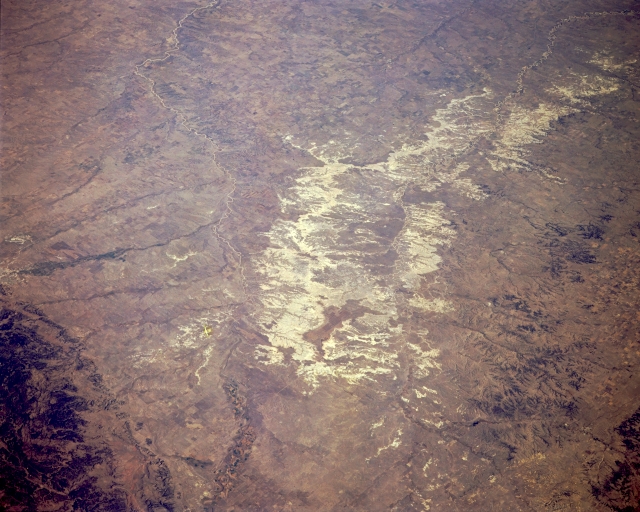 |
| STS068-167-00D The Badlands, South Dakota, U.S.A. October 1994 The badlands of South Dakota, a region of intricately rugged terrain generally consisting of steep slopes, small summits, and closely spaced streams, are featured in this northeast-looking, low-oblique photograph. The region, once an extensive peneplain (a land surface worn almost to a plain), has been dissected into valleys and ridges through stream erosion. The term "badlands" was applied by Indians, trappers, and early explorers of the region because of the difficulties encountered in crossing the barren wastes. The Badlands National Monument, established in 1939, is a 40-mile (64-kilometer) strip of land through which flows the White River. The area covers more than 170 square miles (440 square kilometers) and makes up a small portion of the Pine Ridge Indian Reservation. Visible to the west are the north-flowing Cheyenne River and a small portion of the Black Hills. |
| Images: | All Available Images Low-Resolution 294k |
|
| Mission: | STS068 |
|
| Roll - Frame: | 167 - D |
|
| Geographical Name: | USA-SOUTH DAKOTA |
|
| Features: | CHEYENNE RIVER, BAD LANDS |
|
| Center Lat x Lon: | 43.5N x 102.5W |
|
| Film Exposure: | N | N=Normal exposure, U=Under exposed, O=Over exposed, F=out of Focus |
| Percentage of Cloud Cover-CLDP: | 0 |
|
| Camera:: | LH |
|
| Camera Tilt: | 51 | LO=Low Oblique, HO=High Oblique, NV=Near Vertical |
| Camera Focal Length: | 250 |
|
| Nadir to Photo Center Direction: | NE | The direction from the nadir to the center point, N=North, S=South, E=East, W=West |
| Stereo?: | Y | Y=Yes there is an adjacent picture of the same area, N=No there isn't |
| Orbit Number: | 151 |
|
| Date: | 19941009 | YYYYMMDD |
| Time: | 173540 | GMT HHMMSS |
| Nadir Lat: | 42.0N |
Latitude of suborbital point of spacecraft |
| Nadir Lon: | 104.2W |
Longitude of suborbital point of spacecraft |
| Sun Azimuth: | 158 | Clockwise angle in degrees from north to the sun measured at the nadir point |
| Space Craft Altitude: | 111 | nautical miles |
| Sun Elevation: | 39 | Angle in degrees between the horizon and the sun, measured at the nadir point |
| Land Views: | PLAIN, HILL |
|
| Water Views: | RIVER |
|
| Atmosphere Views: | |
|
| Man Made Views: | |
|
| City Views: | |
|
Photo is not associated with any sequences | ||
| NASA Home Page |
JSC Home Page |
JSC Digital Image Collection |
Earth Science & Remote Sensing |
|
This service is provided by the International Space Station program and the JSC Earth Science & Remote Sensing Unit, ARES Division, Exploration Integration Science Directorate.

|