
Geographic Region: USA-SOUTH DAKOTA
Feature: BLACK HILLS, RAPID CITY
|
Geographic Region: USA-SOUTH DAKOTA Feature: BLACK HILLS, RAPID CITY |
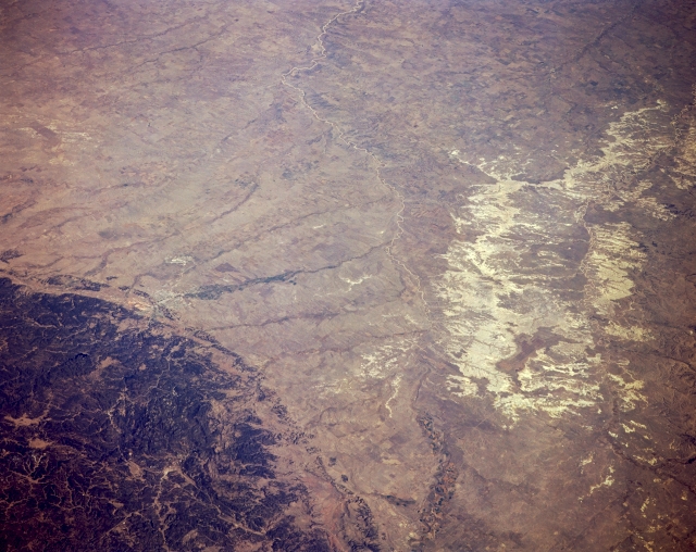 |
| STS068-167-00C Badlands, Cheyenne River, and Black Hills, South Dakota, U.S.A. October 1994 Apparent in this panoramic, northeast-looking, low-oblique photograph of the badlands are the forested, rugged Black Hills and the meandering Cheyenne River. The gullied badlands, within the Pine Ridge Indian Reservation, lie east of the Cheyenne River, which rises in eastern Wyoming and has cut a valley in the soft rock of western South Dakota 300 to 700 feet (92 to 214 meters) deep and several miles wide. The Cheyenne River empties into the part of the Missouri River that forms Lake Oahe in central South Dakota (not visible in this photograph). The Black Hills, named for their heavily forested slopes that appear black from afar, are an elliptical dome dissected by streams. Barely discernible east of the Black Hills is Rapid City. |
| Images: | All Available Images Low-Resolution 294k |
|
| Mission: | STS068 |
|
| Roll - Frame: | 167 - C |
|
| Geographical Name: | USA-SOUTH DAKOTA |
|
| Features: | BLACK HILLS, RAPID CITY |
|
| Center Lat x Lon: | 44.0N x 103W |
|
| Film Exposure: | N | N=Normal exposure, U=Under exposed, O=Over exposed, F=out of Focus |
| Percentage of Cloud Cover-CLDP: | 0 |
|
| Camera:: | LH |
|
| Camera Tilt: | 51 | LO=Low Oblique, HO=High Oblique, NV=Near Vertical |
| Camera Focal Length: | 250 |
|
| Nadir to Photo Center Direction: | NE | The direction from the nadir to the center point, N=North, S=South, E=East, W=West |
| Stereo?: | Y | Y=Yes there is an adjacent picture of the same area, N=No there isn't |
| Orbit Number: | 151 |
|
| Date: | 19941009 | YYYYMMDD |
| Time: | 173535 | GMT HHMMSS |
| Nadir Lat: | 42.3N |
Latitude of suborbital point of spacecraft |
| Nadir Lon: | 104.5W |
Longitude of suborbital point of spacecraft |
| Sun Azimuth: | 157 | Clockwise angle in degrees from north to the sun measured at the nadir point |
| Space Craft Altitude: | 111 | nautical miles |
| Sun Elevation: | 39 | Angle in degrees between the horizon and the sun, measured at the nadir point |
| Land Views: | PLAIN, HILL |
|
| Water Views: | RIVER |
|
| Atmosphere Views: | |
|
| Man Made Views: | |
|
| City Views: | |
|
Photo is not associated with any sequences | ||
| NASA Home Page |
JSC Home Page |
JSC Digital Image Collection |
Earth Science & Remote Sensing |
|
This service is provided by the International Space Station program and the JSC Earth Science & Remote Sensing Unit, ARES Division, Exploration Integration Science Directorate.

|