
Geographic Region: CANADA-O
Feature: L. ERIE, AGRICULTURE,SUNGLINT
|
Geographic Region: CANADA-O Feature: L. ERIE, AGRICULTURE,SUNGLINT |
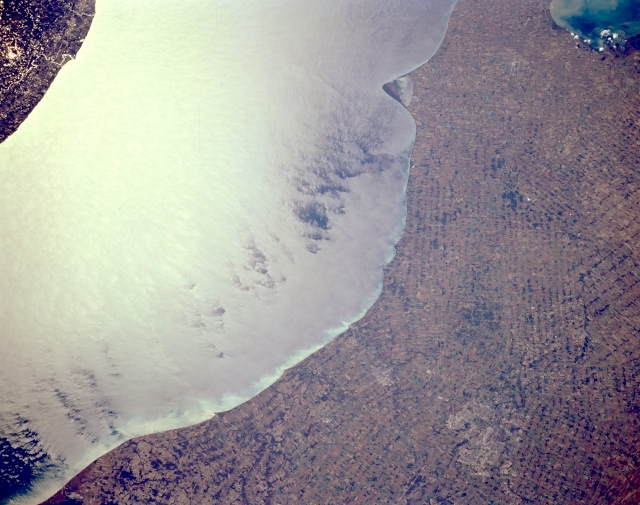 |
| STS068-164-131 Agriculture, Southern Ontario, Canada October 1994 The terrain in this southwest looking view of southern Ontario is gently rolling to flat and the land is almost exclusively used for intensive commercial agriculture. A great many crops, including various kinds of fruits and vegetables, are grown in the mainly sandy soils that are found along the north shore of Lake Erie. Many grain crops are grown in this region to feed dairy cattle. In spite of the many different diagonally intersecting angles that land parcels exhibit across the scene, there is an orderly, regimented alignment to the field patterns. London, the largest city in the picture, is barely observable towards the lower right corner of the image. The V-shaped peninsula (upper center) that juts southward into Lake Erie is Rondeau Provincial Park. The eastern edge of Lake St. Clair is visible in the upper right corner. |
| Images: | All Available Images Low-Resolution 272k |
|
| Mission: | STS068 |
|
| Roll - Frame: | 164 - 131 |
|
| Geographical Name: | CANADA-O |
|
| Features: | L. ERIE, AGRICULTURE,SUNGLINT |
|
| Center Lat x Lon: | 42.5N x 81.5W |
|
| Film Exposure: | N | N=Normal exposure, U=Under exposed, O=Over exposed, F=out of Focus |
| Percentage of Cloud Cover-CLDP: | 0 |
|
| Camera:: | LH |
|
| Camera Tilt: | 48 | LO=Low Oblique, HO=High Oblique, NV=Near Vertical |
| Camera Focal Length: | 250 |
|
| Nadir to Photo Center Direction: | W | The direction from the nadir to the center point, N=North, S=South, E=East, W=West |
| Stereo?: | N | Y=Yes there is an adjacent picture of the same area, N=No there isn't |
| Orbit Number: | 38 |
|
| Date: | 19941002 | YYYYMMDD |
| Time: | 183052 | GMT HHMMSS |
| Nadir Lat: | 43.4N |
Latitude of suborbital point of spacecraft |
| Nadir Lon: | 79.5W |
Longitude of suborbital point of spacecraft |
| Sun Azimuth: | 207 | Clockwise angle in degrees from north to the sun measured at the nadir point |
| Space Craft Altitude: | 118 | nautical miles |
| Sun Elevation: | 39 | Angle in degrees between the horizon and the sun, measured at the nadir point |
| Land Views: | PLAIN |
|
| Water Views: | LAKE |
|
| Atmosphere Views: | |
|
| Man Made Views: | AGRICULTURE |
|
| City Views: | |
|
Photo is not associated with any sequences | ||
| NASA Home Page |
JSC Home Page |
JSC Digital Image Collection |
Earth Science & Remote Sensing |
|
This service is provided by the International Space Station program and the JSC Earth Science & Remote Sensing Unit, ARES Division, Exploration Integration Science Directorate.

|