
Geographic Region: USA-MICHIGAN
Feature: SAGINAW B, AGRICULTURE,SNGLNT
|
Geographic Region: USA-MICHIGAN Feature: SAGINAW B, AGRICULTURE,SNGLNT |
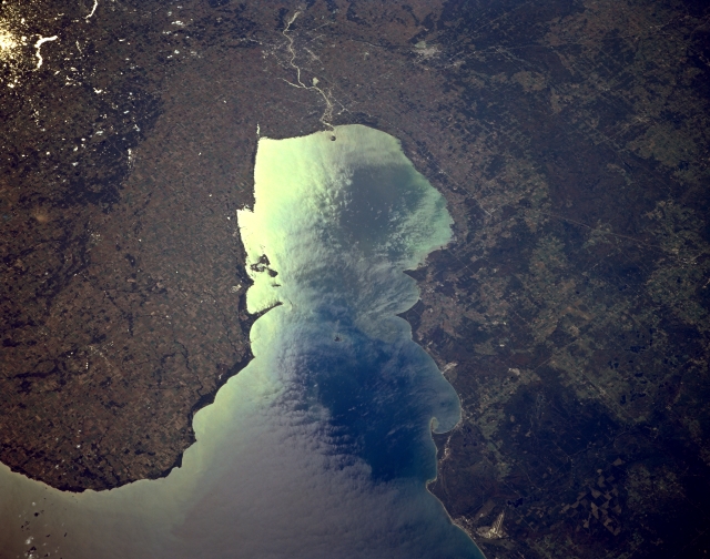 |
| STS068-164-126 Saginaw Bay, Michigan, U.S.A. October 1994 Saginaw Bay, an inlet of Lake Huron, is featured in sunglint in this southwest-looking, low-oblique photograph. Fed mainly by the Saginaw River (near top center), the bay is a fishing and recreational area. Bay City, at the mouth of the Saginaw River, is a major Great Lakes port of entry and shipping center in southern Saginaw Bay. A small portion of Lake Huron is discernible (bottom left). Visible are the runways of Paul B. Wurtsmith Air Force Base (right of bottom center); Huron National Forest to the west; Midland, west of the Saginaw River (right of top center); and Holloway Reservoir (upper left in sunglint). |
| Images: | All Available Images Low-Resolution 270k |
|
| Mission: | STS068 |
|
| Roll - Frame: | 164 - 126 |
|
| Geographical Name: | USA-MICHIGAN |
|
| Features: | SAGINAW B, AGRICULTURE,SNGLNT |
|
| Center Lat x Lon: | 44.0N x 83.5W |
|
| Film Exposure: | N | N=Normal exposure, U=Under exposed, O=Over exposed, F=out of Focus |
| Percentage of Cloud Cover-CLDP: | 5 |
|
| Camera:: | LH |
|
| Camera Tilt: | 44 | LO=Low Oblique, HO=High Oblique, NV=Near Vertical |
| Camera Focal Length: | 250 |
|
| Nadir to Photo Center Direction: | SW | The direction from the nadir to the center point, N=North, S=South, E=East, W=West |
| Stereo?: | Y | Y=Yes there is an adjacent picture of the same area, N=No there isn't |
| Orbit Number: | 38 |
|
| Date: | 19941002 | YYYYMMDD |
| Time: | 183017 | GMT HHMMSS |
| Nadir Lat: | 44.9N |
Latitude of suborbital point of spacecraft |
| Nadir Lon: | 81.8W |
Longitude of suborbital point of spacecraft |
| Sun Azimuth: | 204 | Clockwise angle in degrees from north to the sun measured at the nadir point |
| Space Craft Altitude: | 118 | nautical miles |
| Sun Elevation: | 39 | Angle in degrees between the horizon and the sun, measured at the nadir point |
| Land Views: | |
|
| Water Views: | BAY |
|
| Atmosphere Views: | |
|
| Man Made Views: | AGRICULTURE |
|
| City Views: | |
|
Photo is not associated with any sequences | ||
| NASA Home Page |
JSC Home Page |
JSC Digital Image Collection |
Earth Science & Remote Sensing |
|
This service is provided by the International Space Station program and the JSC Earth Science & Remote Sensing Unit, ARES Division, Exploration Integration Science Directorate.

|