
Geographic Region: USA-MICHIGAN
Feature: GRAND TRAVERSE B,AGRICULTURE,L
|
Geographic Region: USA-MICHIGAN Feature: GRAND TRAVERSE B,AGRICULTURE,L |
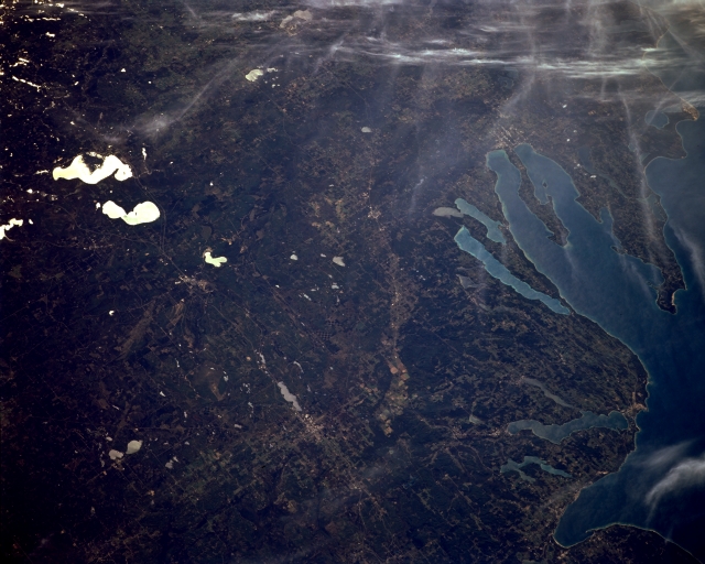 |
| STS068-164-124 Grand Traverse Bay, Michigan, U.S.A October 1994 Featured in this southwest-looking, low-oblique photograph are the northwest forest and agricultural lands adjacent to Grand Traverse Bay (bottom right). An arm of Lake Michigan, the bay, 32 miles (52 kilometers) long and up to 10 miles (16 kilometers) wide, is known for fishing and boating in this popular year-round vacation and resort area. The sandy soils near the shores of Lake Michigan are excellent for fruit-growing, especially cherries. Many lakes are scattered throughout the area--Houghton Lake, the state's largest inland lake, and Higgins Lake to its north (upper left); West and East Twin Lakes to the northeast (lower left); Walloon Lake and larger Charlevoix Lake south of Little Traverse Bay (near bottom right); and elongated Torch Lake and smaller Elk Lake just east of the Grand Traverse Bay shore, at the south end of which is Traverse City (barely discernible). |
| Images: | All Available Images Low-Resolution 272k |
|
| Mission: | STS068 |
|
| Roll - Frame: | 164 - 124 |
|
| Geographical Name: | USA-MICHIGAN |
|
| Features: | GRAND TRAVERSE B,AGRICULTURE,L |
|
| Center Lat x Lon: | 45.0N x 85W |
|
| Film Exposure: | N | N=Normal exposure, U=Under exposed, O=Over exposed, F=out of Focus |
| Percentage of Cloud Cover-CLDP: | 5 |
|
| Camera:: | LH |
|
| Camera Tilt: | 44 | LO=Low Oblique, HO=High Oblique, NV=Near Vertical |
| Camera Focal Length: | 250 |
|
| Nadir to Photo Center Direction: | W | The direction from the nadir to the center point, N=North, S=South, E=East, W=West |
| Stereo?: | Y | Y=Yes there is an adjacent picture of the same area, N=No there isn't |
| Orbit Number: | 38 |
|
| Date: | 19941002 | YYYYMMDD |
| Time: | 182956 | GMT HHMMSS |
| Nadir Lat: | 45.8N |
Latitude of suborbital point of spacecraft |
| Nadir Lon: | 83.3W |
Longitude of suborbital point of spacecraft |
| Sun Azimuth: | 202 | Clockwise angle in degrees from north to the sun measured at the nadir point |
| Space Craft Altitude: | 118 | nautical miles |
| Sun Elevation: | 38 | Angle in degrees between the horizon and the sun, measured at the nadir point |
| Land Views: | FOREST |
|
| Water Views: | BAY, LAKE |
|
| Atmosphere Views: | |
|
| Man Made Views: | |
|
| City Views: | |
|
Photo is not associated with any sequences | ||
| NASA Home Page |
JSC Home Page |
JSC Digital Image Collection |
Earth Science & Remote Sensing |
|
This service is provided by the International Space Station program and the JSC Earth Science & Remote Sensing Unit, ARES Division, Exploration Integration Science Directorate.

|