Geographic Region: CHINA
Feature: TAKLA MAKAN DES, DRAIN.
|
Geographic Region: CHINA Feature: TAKLA MAKAN DES, DRAIN. |
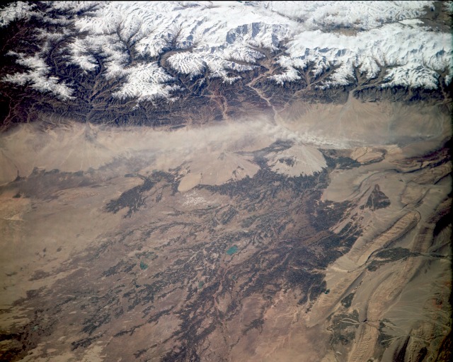 |
| STS068-163-136 Western Xinjiang Province, China October 1994 The snowcapped northwest Kunlun Mountains and Tien Mountains almost pinch together at the western end of the arid Tarim Basin in extreme western China as pictured in this low-oblique, southwest-looking photograph. The large alluvial fans along the northeast slopes of these mountains are the result of years of material deposition from glacial scouring and snowmelt. Many individual glaciers and glacial features are visible in this photograph. Because of the extensive browns and tans within the arid western Tarim Basin, surface water is assumed to be available for irrigation farming. No perennial rivers flow through this desert; only intermittent streams and rivers that originate in the surrounding mountains flow into the basin. Proof that the tributaries diminish and the water quality deteriorates as these streams flow from their source is provided as the browns become lighter with increased distance from water sources. Although not discernible at this scale, the city of Kashi is slightly west of center within the cultivated brown field patterns. A small dust storm appears to be blowing from west to east near the base of the alluvial fans at the foot of the Kunlun Mountains. |
| Images: | All Available Images Low-Resolution 128k |
|
| Mission: | STS068 |
|
| Roll - Frame: | 163 - 136 |
|
| Geographical Name: | CHINA |
|
| Features: | TAKLA MAKAN DES, DRAIN. |
|
| Center Lat x Lon: | 39.0N x 76.0E |
|
| Film Exposure: | N | N=Normal exposure, U=Under exposed, O=Over exposed, F=out of Focus |
| Percentage of Cloud Cover-CLDP: | 5 |
|
| Camera:: | LH |
|
| Camera Tilt: | 55 | LO=Low Oblique, HO=High Oblique, NV=Near Vertical |
| Camera Focal Length: | 250 |
|
| Nadir to Photo Center Direction: | SW | The direction from the nadir to the center point, N=North, S=South, E=East, W=West |
| Stereo?: | Y | Y=Yes there is an adjacent picture of the same area, N=No there isn't |
| Orbit Number: | 111 |
|
| Date: | 19941007 | YYYYMMDD |
| Time: | 063241 | GMT HHMMSS |
| Nadir Lat: | 40.2N |
Latitude of suborbital point of spacecraft |
| Nadir Lon: | 78.4E |
Longitude of suborbital point of spacecraft |
| Sun Azimuth: | 179 | Clockwise angle in degrees from north to the sun measured at the nadir point |
| Space Craft Altitude: | 115 | nautical miles |
| Sun Elevation: | 45 | Angle in degrees between the horizon and the sun, measured at the nadir point |
| Land Views: | MOUNTAIN, DESERT, BASIN |
|
| Water Views: | RIVER, DELTA |
|
| Atmosphere Views: | DUST |
|
| Man Made Views: | AGRICULTURE |
|
| City Views: | |
|
Photo is not associated with any sequences | ||
| NASA Home Page |
JSC Home Page |
JSC Digital Image Collection |
Earth Science & Remote Sensing |
|
This service is provided by the International Space Station program and the JSC Earth Science & Remote Sensing Unit, ARES Division, Exploration Integration Science Directorate.

|