Geographic Region: CHINA
Feature: GOBI DESERT,YELLOW R,MTS
|
Geographic Region: CHINA Feature: GOBI DESERT,YELLOW R,MTS |
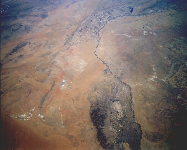 |
| STS068-162-120 Ordos Desert and the Huang He (Yellow River), China October 1994 The arid steppes in this low-oblique, generally north-looking photograph is a transition zone between China (People's Republic of China) to the south and the independent buffer state of Mongolia to the north. The photograph shows part of the Huang He (Yellow River) as it flows north and then east through the Ordos Desert. The climate of this margin of the Gobi Desert is characterized by chronic droughts, hot summers, and bitterly cold winters. The only true settlements are found along the floodplains of the Huang He where sufficient quantities of water are available for intensive irrigated farming. Two distinct agricultural areas are visible in the photograph--a highly cultivated area between the Helan Mountains (a small, north-south-oriented range near the southern boundary of the photograph) and the Huang He and another farther north where the Huang He bends east. The city of Baotou is located east of this second area, along the northern shore of the Huang He. Several highly reflective dry salt lakes are scattered east and west of the river. The sizable towns of Yinchuan and Xincheng are barely recognizable in the cultivated fields east of the Helan Mountain along the southern edge of the photograph. (Refer to STS-068-239-083 for a detailed photograph of floodplain farming east of the Helan Mountains.) |
| Images: | All Available Images Low-Resolution 89k |
|
| Mission: | STS068 |
|
| Roll - Frame: | 162 - 120 |
|
| Geographical Name: | CHINA |
|
| Features: | GOBI DESERT,YELLOW R,MTS |
|
| Center Lat x Lon: | 40.0N x 106.5E |
|
| Film Exposure: | N | N=Normal exposure, U=Under exposed, O=Over exposed, F=out of Focus |
| Percentage of Cloud Cover-CLDP: | 5 |
|
| Camera:: | LH |
|
| Camera Tilt: | 48 | LO=Low Oblique, HO=High Oblique, NV=Near Vertical |
| Camera Focal Length: | 90 |
|
| Nadir to Photo Center Direction: | N | The direction from the nadir to the center point, N=North, S=South, E=East, W=West |
| Stereo?: | Y | Y=Yes there is an adjacent picture of the same area, N=No there isn't |
| Orbit Number: | 62 |
|
| Date: | 19941004 | YYYYMMDD |
| Time: | 060418 | GMT HHMMSS |
| Nadir Lat: | 37.9N |
Latitude of suborbital point of spacecraft |
| Nadir Lon: | 106.0E |
Longitude of suborbital point of spacecraft |
| Sun Azimuth: | 208 | Clockwise angle in degrees from north to the sun measured at the nadir point |
| Space Craft Altitude: | 117 | nautical miles |
| Sun Elevation: | 44 | Angle in degrees between the horizon and the sun, measured at the nadir point |
| Land Views: | VALLEY, DESERT, MOUNTAIN |
|
| Water Views: | RIVER |
|
| Atmosphere Views: | |
|
| Man Made Views: | AGRICULTURE |
|
| City Views: | |
|
Photo is not associated with any sequences | ||
| NASA Home Page |
JSC Home Page |
JSC Digital Image Collection |
Earth Science & Remote Sensing |
|
This service is provided by the International Space Station program and the JSC Earth Science & Remote Sensing Unit, ARES Division, Exploration Integration Science Directorate.

|