
Geographic Region: USA-MONTANA
Feature: ROCKY MTS,KOOTENAY RIVER
|
Geographic Region: USA-MONTANA Feature: ROCKY MTS,KOOTENAY RIVER |
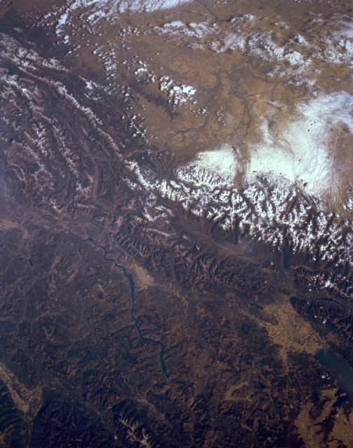 |
| STS068-161-041 Rocky Mountains, British Columbia, Canada October 1994 Parts of southeast British Columbia, southwest Alberta, and northwest Montana are visible in this synoptic, northeast-looking view of the Rocky Mountains. North of the Canadian/U.S. border the snow covered mountain ridgelines are easily discernible. The lighter colored landscape east of the Rocky Mountains shows part of the rolling plains of southwest Alberta. These lighter colored grasslands contrasts with the darker, forested mountainous slopes of the Rockies. The very bright, white feature near the right-center margin of the picture shows an area where a recent snowfall has covered a section of the plains in southwest Alberta. The Kootenay River is visible as it flows south between some of the lower elevation ranges of the Rocky Mountains. The dark blue feature in the extreme lower right corner of the picture is the northern end of Flathead Lake, Montana. The lighter colored terrain immediately north of the lake is a relatively flat valley where Kalispell, Montana is located. |
| Images: | All Available Images Low-Resolution 299k |
|
| Mission: | STS068 |
|
| Roll - Frame: | 161 - 41 |
|
| Geographical Name: | USA-MONTANA |
|
| Features: | ROCKY MTS,KOOTENAY RIVER |
|
| Center Lat x Lon: | 49.0N x 114W |
|
| Film Exposure: | N | N=Normal exposure, U=Under exposed, O=Over exposed, F=out of Focus |
| Percentage of Cloud Cover-CLDP: | 10 |
|
| Camera:: | LH |
|
| Camera Tilt: | 25 | LO=Low Oblique, HO=High Oblique, NV=Near Vertical |
| Camera Focal Length: | 90 |
|
| Nadir to Photo Center Direction: | NE | The direction from the nadir to the center point, N=North, S=South, E=East, W=West |
| Stereo?: | N | Y=Yes there is an adjacent picture of the same area, N=No there isn't |
| Orbit Number: | 119 |
|
| Date: | 19941007 | YYYYMMDD |
| Time: | 181901 | GMT HHMMSS |
| Nadir Lat: | 48.4N |
Latitude of suborbital point of spacecraft |
| Nadir Lon: | 114.6W |
Longitude of suborbital point of spacecraft |
| Sun Azimuth: | 160 | Clockwise angle in degrees from north to the sun measured at the nadir point |
| Space Craft Altitude: | 111 | nautical miles |
| Sun Elevation: | 34 | Angle in degrees between the horizon and the sun, measured at the nadir point |
| Land Views: | MOUNTAIN, PLAIN, VALLEY |
|
| Water Views: | RIVER |
|
| Atmosphere Views: | |
|
| Man Made Views: | |
|
| City Views: | |
|
Photo is not associated with any sequences | ||
| NASA Home Page |
JSC Home Page |
JSC Digital Image Collection |
Earth Science & Remote Sensing |
|
This service is provided by the International Space Station program and the JSC Earth Science & Remote Sensing Unit, ARES Division, Exploration Integration Science Directorate.

|