Geographic Region: RUSSIAN FEDERATION
Feature: CHANY LAKE AREA
|
Geographic Region: RUSSIAN FEDERATION Feature: CHANY LAKE AREA |
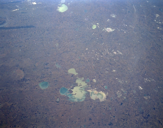 |
| STS068-153-017 Lake Chany Area, Russia October 1994 This southerly-looking, synoptic view shows a large section of the vast West Siberian Plain with Lake Chany (large, irregular-shape feature) located towards the bottom center of the image. Although Lake Chany is not well known outside of Russia, it is one of the largest lakes in Russia. Lake Chany is a shallow, freshwater lake that has a fluctuating water level, which can change from season to season and year to year. At the time that this picture was taken, the water level in the lake appears to be low, even to the point where the western end and the northeast corner of the lake seem to be separate lakes. A variety of ecosystems that surround the lake include a mixture of wetlands, salt marshes, and a mixture of birch and aspen forests. The landscape is so flat in this region between the Ob River (east) and Irtysh (west) Rivers that it consists of poorly drained marshlands with only limited accessibility. The light-colored features many oval-in- shape, are lakes or salt flats (dry lakes). Kulundinskoye Lake is the oval-shaped lake near the top center. The dark-colored, linear feature (upper left) is a forested, swampy finger of the Ob River. Lake Chany in particular is critically important for the migratory birds of Siberia. |
| Images: | All Available Images Low-Resolution 280k |
|
| Mission: | STS068 |
|
| Roll - Frame: | 153 - 17 |
|
| Geographical Name: | RUSSIAN FEDERATION |
|
| Features: | CHANY LAKE AREA |
|
| Center Lat x Lon: | 54.5N x 78.0E |
|
| Film Exposure: | N | N=Normal exposure, U=Under exposed, O=Over exposed, F=out of Focus |
| Percentage of Cloud Cover-CLDP: | 0 |
|
| Camera:: | LH |
|
| Camera Tilt: | 30 | LO=Low Oblique, HO=High Oblique, NV=Near Vertical |
| Camera Focal Length: | 250 |
|
| Nadir to Photo Center Direction: | S | The direction from the nadir to the center point, N=North, S=South, E=East, W=West |
| Stereo?: | Y | Y=Yes there is an adjacent picture of the same area, N=No there isn't |
| Orbit Number: | 12 |
|
| Date: | 19941001 | YYYYMMDD |
| Time: | 034930 | GMT HHMMSS |
| Nadir Lat: | 55.5N |
Latitude of suborbital point of spacecraft |
| Nadir Lon: | 77.5E |
Longitude of suborbital point of spacecraft |
| Sun Azimuth: | 133 | Clockwise angle in degrees from north to the sun measured at the nadir point |
| Space Craft Altitude: | 118 | nautical miles |
| Sun Elevation: | 22 | Angle in degrees between the horizon and the sun, measured at the nadir point |
| Land Views: | PLAIN |
|
| Water Views: | LAKE |
|
| Atmosphere Views: | |
|
| Man Made Views: | |
|
| City Views: | |
|
Photo is not associated with any sequences | ||
| NASA Home Page |
JSC Home Page |
JSC Digital Image Collection |
Earth Science & Remote Sensing |
|
This service is provided by the International Space Station program and the JSC Earth Science & Remote Sensing Unit, ARES Division, Exploration Integration Science Directorate.

|