
Geographic Region: USA-CALIFORNIA
Feature: DEATH VALLEY AREA
|
Geographic Region: USA-CALIFORNIA Feature: DEATH VALLEY AREA |
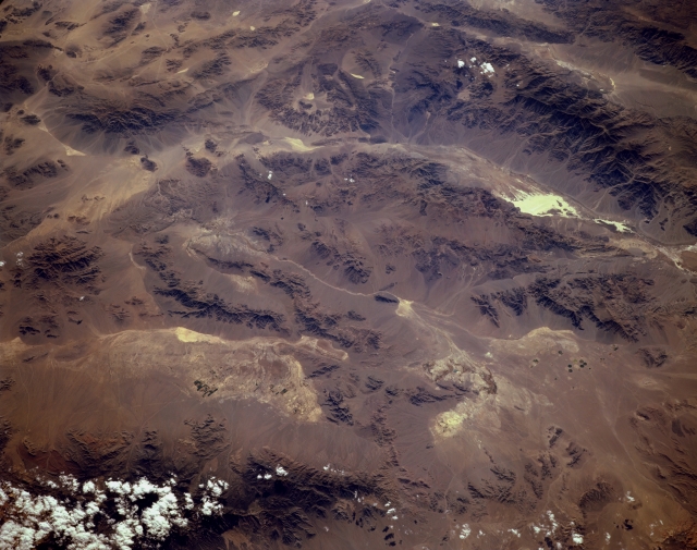 |
| STS068-150-024 Pahrump Valley and Death Valley, Nevada and California, U.S.A. October 1994 Many arid landforms of California and southwestern Nevada are captured in this low-oblique, generally west-looking photograph. At the bottom of the photograph, the partially cloud-covered Spring Mountains are visible, immediately west of which the well-defined drainage pattern of the sparsely vegetated Pahrump Valley can be traced. The intermittently flowing Amargosa River heads southward, makes a U-turn around the southern end of the Amargosa Mountains, and finally flows northwesterly into Death Valley. The very white area is salt residue that has been deposited on the surface of Death Valley Dry Lake [282 feet (86 meters) below sea level--the lowest point in North America]. Because this region receives an average of only 2 inches (5 centimeters) of precipitation per year, the water courses normally do not transport much water. The large Panamint Mountains are visible immediately west of Death Valley. Small, circular, pivot irrigation fields in the Amargosa Desert are the only visual evidence of human activity in this blistering desert landscape. |
| Images: | All Available Images Low-Resolution 273k |
|
| Mission: | STS068 |
|
| Roll - Frame: | 150 - 24 |
|
| Geographical Name: | USA-CALIFORNIA |
|
| Features: | DEATH VALLEY AREA |
|
| Center Lat x Lon: | 36.0N x 116.5W |
|
| Film Exposure: | N | N=Normal exposure, U=Under exposed, O=Over exposed, F=out of Focus |
| Percentage of Cloud Cover-CLDP: | 5 |
|
| Camera:: | HB |
|
| Camera Tilt: | 46 | LO=Low Oblique, HO=High Oblique, NV=Near Vertical |
| Camera Focal Length: | 250 |
|
| Nadir to Photo Center Direction: | SW | The direction from the nadir to the center point, N=North, S=South, E=East, W=West |
| Stereo?: | Y | Y=Yes there is an adjacent picture of the same area, N=No there isn't |
| Orbit Number: | 8 |
|
| Date: | 19940930 | YYYYMMDD |
| Time: | 220742 | GMT HHMMSS |
| Nadir Lat: | 37.4N |
Latitude of suborbital point of spacecraft |
| Nadir Lon: | 115W |
Longitude of suborbital point of spacecraft |
| Sun Azimuth: | 231 | Clockwise angle in degrees from north to the sun measured at the nadir point |
| Space Craft Altitude: | 118 | nautical miles |
| Sun Elevation: | 36 | Angle in degrees between the horizon and the sun, measured at the nadir point |
| Land Views: | DESERT, VALLEY, MOUNTAIN |
|
| Water Views: | RIVER, PLAYA |
|
| Atmosphere Views: | |
|
| Man Made Views: | |
|
| City Views: | |
|
Photo is not associated with any sequences | ||
| NASA Home Page |
JSC Home Page |
JSC Digital Image Collection |
Earth Science & Remote Sensing |
|
This service is provided by the International Space Station program and the JSC Earth Science & Remote Sensing Unit, ARES Division, Exploration Integration Science Directorate.

|