
Geographic Region: BELIZE
Feature: REEFS, TURNEFFE ISLAND
|
Geographic Region: BELIZE Feature: REEFS, TURNEFFE ISLAND |
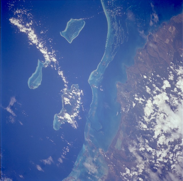 |
| STS067-716A-066 Reefs, Belize March 1995 Formerly known as British Honduras, the low and marshy coastal plain of the small country of Belize is visible in this low-oblique, southeast-looking photograph. A popular site for skin diving and snorkeling, an almost unbroken chain of coral reefs and shoals stretches in the clear waters of the western Caribbean Sea approximately 12 miles (20 kilometers) from the east coast of Belize. Three large concentrations of reefs and islands farther east are the Turneffe Islands (partially obscured by clouds), Lighthouse Reef (easternmost and fish-shaped), and Glover Reef. The relatively remote location and the pristine environment of Belize provide natural attractions to the area. The entire country of Belize has a population of slightly more than 200 000; population density is very low. The largest city, Belize City (population of approximately 50 000), is barely evident on the small peninsula near the north edge of the photograph. Sugar and citrus fruits are the country's two leading agricultural products; tourism is becoming a viable industry. Ethnically Belize is more closely tied to its Caribbean island neighbors than to the Spanish-speaking countries of Central America. |
| Images: | All Available Images Low-Resolution 100k |
|
| Mission: | STS067 |
|
| Roll - Frame: | 716A - 66 |
|
| Geographical Name: | BELIZE |
|
| Features: | REEFS, TURNEFFE ISLAND |
|
| Center Lat x Lon: | 17.5N x 88W |
|
| Film Exposure: | N | N=Normal exposure, U=Under exposed, O=Over exposed, F=out of Focus |
| Percentage of Cloud Cover-CLDP: | 20 |
|
| Camera:: | HB |
|
| Camera Tilt: | LO | LO=Low Oblique, HO=High Oblique, NV=Near Vertical |
| Camera Focal Length: | 250 |
|
| Nadir to Photo Center Direction: | W | The direction from the nadir to the center point, N=North, S=South, E=East, W=West |
| Stereo?: | Y | Y=Yes there is an adjacent picture of the same area, N=No there isn't |
| Orbit Number: | |
|
| Date: | 199503__ | YYYYMMDD |
| Time: | GMT HHMMSS |
|
| Nadir Lat: | N |
Latitude of suborbital point of spacecraft |
| Nadir Lon: | E |
Longitude of suborbital point of spacecraft |
| Sun Azimuth: | Clockwise angle in degrees from north to the sun measured at the nadir point |
|
| Space Craft Altitude: | nautical miles |
|
| Sun Elevation: | Angle in degrees between the horizon and the sun, measured at the nadir point |
|
| Land Views: | COAST |
|
| Water Views: | SEA, LAGOON, REEF |
|
| Atmosphere Views: | |
|
| Man Made Views: | |
|
| City Views: | |
|
Photo is not associated with any sequences | ||
| NASA Home Page |
JSC Home Page |
JSC Digital Image Collection |
Earth Science & Remote Sensing |
|
This service is provided by the International Space Station program and the JSC Earth Science & Remote Sensing Unit, ARES Division, Exploration Integration Science Directorate.

|