
Geographic Region: DEM. REP. OF CONGO
Feature: ZAIRE RIVER, L. TUMBA
|
Geographic Region: DEM. REP. OF CONGO Feature: ZAIRE RIVER, L. TUMBA |
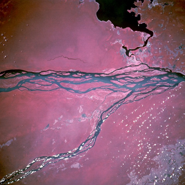 |
| STS067-703D-093 Zaire (Congo) River, Zaire March 1995 The dense swamp at the confluence of the Zaire (Congo) and Ubangi (Oubangui) Rivers in northwestern Zaire is greatly enhanced by this color infrared photograph. The uniform, reddish color that dominates this scene shows a virtually unbroken tropical rain forest canopy. The pale pink areas, mostly along the shores of the rivers and Lake Tumba (large, dark feature south of the Zaire River), show locations of slash-and-burn agriculture. Much of the virgin floodplain forest in this region has been spared the fate of other equatorial rain forests because of its hostile terrain. The whitish, highly reflective areas in the south-flowing Ubangi River are large sand bars. Many southwest-flowing channels of the Zaire River form numerous islands and are easily discriminated from the surrounding jungle. Although the Zaire is a major river, its use as a major transportation artery has been hindered by impassable rapids at several locations. |
| Images: | All Available Images Low-Resolution 124k |
|
| Mission: | STS067 |
|
| Roll - Frame: | 703D - 93 |
|
| Geographical Name: | DEM. REP. OF CONGO |
|
| Features: | ZAIRE RIVER, L. TUMBA |
|
| Center Lat x Lon: | 0.5S x 17.5E |
|
| Film Exposure: | N | N=Normal exposure, U=Under exposed, O=Over exposed, F=out of Focus |
| Percentage of Cloud Cover-CLDP: | 5 |
|
| Camera:: | HB |
|
| Camera Tilt: | NV | LO=Low Oblique, HO=High Oblique, NV=Near Vertical |
| Camera Focal Length: | 250 |
|
| Nadir to Photo Center Direction: | The direction from the nadir to the center point, N=North, S=South, E=East, W=West |
|
| Stereo?: | N | Y=Yes there is an adjacent picture of the same area, N=No there isn't |
| Orbit Number: | |
|
| Date: | 199503__ | YYYYMMDD |
| Time: | GMT HHMMSS |
|
| Nadir Lat: | N |
Latitude of suborbital point of spacecraft |
| Nadir Lon: | E |
Longitude of suborbital point of spacecraft |
| Sun Azimuth: | Clockwise angle in degrees from north to the sun measured at the nadir point |
|
| Space Craft Altitude: | nautical miles |
|
| Sun Elevation: | Angle in degrees between the horizon and the sun, measured at the nadir point |
|
| Land Views: | FOREST, PLAIN |
|
| Water Views: | RIVER, LAKE |
|
| Atmosphere Views: | |
|
| Man Made Views: | AGRICULTURE |
|
| City Views: | |
|
Photo is not associated with any sequences | ||
| NASA Home Page |
JSC Home Page |
JSC Digital Image Collection |
Earth Science & Remote Sensing |
|
This service is provided by the International Space Station program and the JSC Earth Science & Remote Sensing Unit, ARES Division, Exploration Integration Science Directorate.

|