
Geographic Region: USA-DELAWARE
Feature: DELMARVA PENINSULA
|
Geographic Region: USA-DELAWARE Feature: DELMARVA PENINSULA |
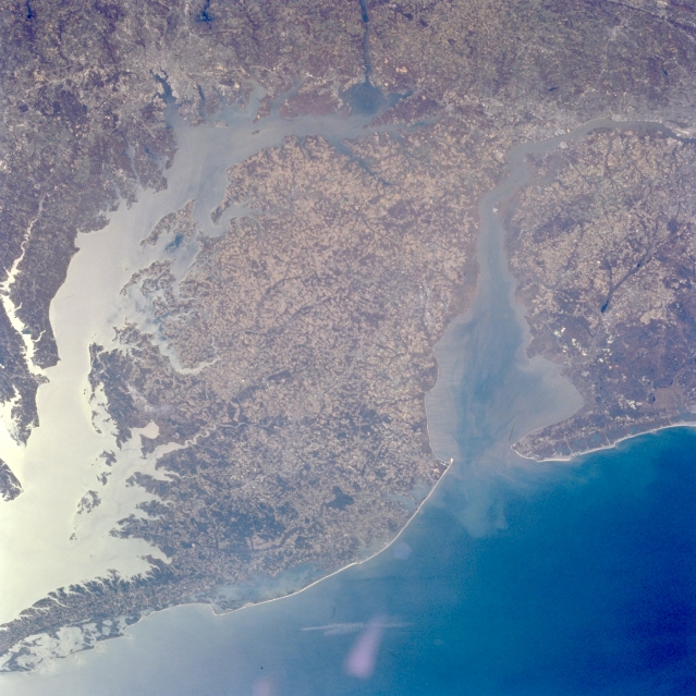 |
| STS066-096-081 Delmarva Peninsula, Maryland, Delaware, U.S.A. November 1994 The Delmarva (state of Delaware and portions of the states of Maryland and Virginia) Peninsula can be seen in this west-northwest-looking view. The 180 mile (290 km) long peninsula is surrounded by water on three sides. Delaware Bay is to the peninsula's north (right); the Atlantic Ocean to the peninsula's east (bottom right); and Chesapeake Bay to the peninsula's west (left). The Delmarva Peninsula has low terrain with some forest lands and many agricultural fields. The western shore of the peninsula is irregular and marshy, while the eastern shore is rather straight with sand beaches and offshore bars. The extreme southern portion of the state of New Jersey, along with Cape May, can be seen at the right center of the image. The city of Baltimore, Maryland, is discernible in the upper left portion of the image. |
| Images: | All Available Images Low-Resolution 339k |
|
| Mission: | STS066 |
|
| Roll - Frame: | 96 - 81 |
|
| Geographical Name: | USA-DELAWARE |
|
| Features: | DELMARVA PENINSULA |
|
| Center Lat x Lon: | 38.5N x 75.5W |
|
| Film Exposure: | N | N=Normal exposure, U=Under exposed, O=Over exposed, F=out of Focus |
| Percentage of Cloud Cover-CLDP: | 0 |
|
| Camera:: | HB |
|
| Camera Tilt: | 40 | LO=Low Oblique, HO=High Oblique, NV=Near Vertical |
| Camera Focal Length: | 100 |
|
| Nadir to Photo Center Direction: | S | The direction from the nadir to the center point, N=North, S=South, E=East, W=West |
| Stereo?: | N | Y=Yes there is an adjacent picture of the same area, N=No there isn't |
| Orbit Number: | 17 |
|
| Date: | 19941104 | YYYYMMDD |
| Time: | 171729 | GMT HHMMSS |
| Nadir Lat: | 40.6N |
Latitude of suborbital point of spacecraft |
| Nadir Lon: | 76.4W |
Longitude of suborbital point of spacecraft |
| Sun Azimuth: | 188 | Clockwise angle in degrees from north to the sun measured at the nadir point |
| Space Craft Altitude: | 163 | nautical miles |
| Sun Elevation: | 34 | Angle in degrees between the horizon and the sun, measured at the nadir point |
| Land Views: | PENINSULA, COAST, VALLEY |
|
| Water Views: | BAY, SEDIMENT |
|
| Atmosphere Views: | |
|
| Man Made Views: | AGRICULTURE |
|
| City Views: | |
|
Photo is not associated with any sequences | ||
| NASA Home Page |
JSC Home Page |
JSC Digital Image Collection |
Earth Science & Remote Sensing |
|
This service is provided by the International Space Station program and the JSC Earth Science & Remote Sensing Unit, ARES Division, Exploration Integration Science Directorate.

|