Geographic Region: CHINA
Feature: GOBI DESERT, DUST STORM
|
Geographic Region: CHINA Feature: GOBI DESERT, DUST STORM |
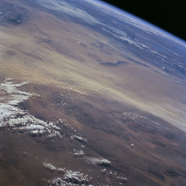 |
| STS066-095-095 Dust Storm, Gobi Desert, China November 1994 This high oblique, southeasterly view shows a large dust storm in progress (light-color, east-west swath) along the southern margin of the Gobi Desert. Tremendous quantities of soil are transported from the deserts of west central China eastward. The westerly winds carry fine-grained silt from western China towards east China where large deposits of loess have created vertical cliffs that are several hundred feet high in the vicinity of the Huang Ho (formerly called the Yellow River). Recognizable physical landforms in this image include the Helan Mountains (small dark area - upper left); a very small section of the Huang Ho (light colored linear feature east of Helan Mountains); and the northeast - southwest aligned Yabral Mountains (elongated, dark feature slightly above and right of center). |
| Images: | All Available Images Low-Resolution 295k |
|
| Mission: | STS066 |
|
| Roll - Frame: | 95 - 95 |
|
| Geographical Name: | CHINA |
|
| Features: | GOBI DESERT, DUST STORM |
|
| Center Lat x Lon: | 39.5N x 101.0E |
|
| Film Exposure: | N | N=Normal exposure, U=Under exposed, O=Over exposed, F=out of Focus |
| Percentage of Cloud Cover-CLDP: | 10 |
|
| Camera:: | HB |
|
| Camera Tilt: | HO | LO=Low Oblique, HO=High Oblique, NV=Near Vertical |
| Camera Focal Length: | 100 |
|
| Nadir to Photo Center Direction: | SW | The direction from the nadir to the center point, N=North, S=South, E=East, W=West |
| Stereo?: | N | Y=Yes there is an adjacent picture of the same area, N=No there isn't |
| Orbit Number: | 25 |
|
| Date: | 19941105 | YYYYMMDD |
| Time: | 052349 | GMT HHMMSS |
| Nadir Lat: | 45.9N |
Latitude of suborbital point of spacecraft |
| Nadir Lon: | 107.5E |
Longitude of suborbital point of spacecraft |
| Sun Azimuth: | 194 | Clockwise angle in degrees from north to the sun measured at the nadir point |
| Space Craft Altitude: | 164 | nautical miles |
| Sun Elevation: | 28 | Angle in degrees between the horizon and the sun, measured at the nadir point |
| Land Views: | DESERT, MOUNTAIN |
|
| Water Views: | |
|
| Atmosphere Views: | DUST |
|
| Man Made Views: | |
|
| City Views: | |
|
Photo is not associated with any sequences | ||
| NASA Home Page |
JSC Home Page |
JSC Digital Image Collection |
Earth Science & Remote Sensing |
|
This service is provided by the International Space Station program and the JSC Earth Science & Remote Sensing Unit, ARES Division, Exploration Integration Science Directorate.

|