Geographic Region: TAIWAN
Feature: MTS.,RIVERS,CITIES,HAZE
|
Geographic Region: TAIWAN Feature: MTS.,RIVERS,CITIES,HAZE |
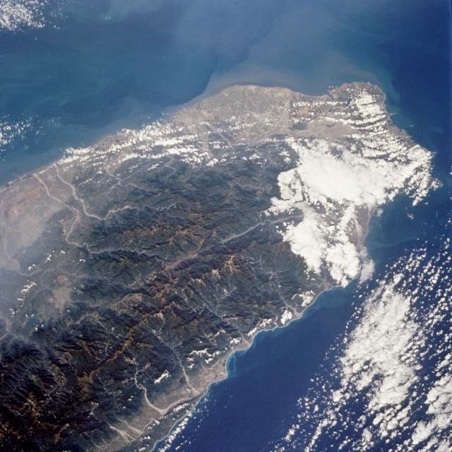 |
| STS066-089-069 Taiwan November 1994 The island of Taiwan (National Republic of China) has a population of more than 21 million in an area the size of Switzerland; this photograph shows the northern half of the island. Most of the inhabitants live along the plains that extend along the entire west coast. T'ai-pei, the capital with a population of almost 3 million, is located near the northern tip of the island. The small scale of the photograph and the gross resolution allow only identification of the general location of the urban area at the northern end of the island. Many short rivers that drain east and west arise in the Chungyang Mountains that extend for almost the entire length of the country. The mountains of Taiwan, with some of the central ranges rising to altitudes of more than 10 000 feet (3000 meters), are young and still actively undergoing tectonic movement. Taiwan is bordered on the west by the Taiwan Strait, which separates the country from mainland China (People's Republic of China), and on the east by the Pacific Ocean. Taiwan is an amazing economic success story; along with Japan, Hong Kong, South Korea, and Singapore, it is considered to be one of the "Pacific Rim Economic Tigers." |
| Images: | All Available Images Low-Resolution 144k |
|
| Mission: | STS066 |
|
| Roll - Frame: | 89 - 69 |
|
| Geographical Name: | TAIWAN |
|
| Features: | MTS.,RIVERS,CITIES,HAZE |
|
| Center Lat x Lon: | 24.5N x 121.5E |
|
| Film Exposure: | N | N=Normal exposure, U=Under exposed, O=Over exposed, F=out of Focus |
| Percentage of Cloud Cover-CLDP: | 30 |
|
| Camera:: | HB |
|
| Camera Tilt: | 25 | LO=Low Oblique, HO=High Oblique, NV=Near Vertical |
| Camera Focal Length: | 100 |
|
| Nadir to Photo Center Direction: | NW | The direction from the nadir to the center point, N=North, S=South, E=East, W=West |
| Stereo?: | N | Y=Yes there is an adjacent picture of the same area, N=No there isn't |
| Orbit Number: | 39 |
|
| Date: | 19941106 | YYYYMMDD |
| Time: | 022321 | GMT HHMMSS |
| Nadir Lat: | 23.4N |
Latitude of suborbital point of spacecraft |
| Nadir Lon: | 122.1E |
Longitude of suborbital point of spacecraft |
| Sun Azimuth: | 154 | Clockwise angle in degrees from north to the sun measured at the nadir point |
| Space Craft Altitude: | 162 | nautical miles |
| Sun Elevation: | 47 | Angle in degrees between the horizon and the sun, measured at the nadir point |
| Land Views: | COAST, ISLAND, FOREST, MOUNTAIN, VALLEY, PLAIN |
|
| Water Views: | RIVER, SEDIMENT, STRAIT |
|
| Atmosphere Views: | |
|
| Man Made Views: | URBAN AREA |
|
| City Views: | |
|
Photo is not associated with any sequences | ||
| NASA Home Page |
JSC Home Page |
JSC Digital Image Collection |
Earth Science & Remote Sensing |
|
This service is provided by the International Space Station program and the JSC Earth Science & Remote Sensing Unit, ARES Division, Exploration Integration Science Directorate.

|