
Geographic Region: USA-ARIZONA
Feature: HAVASU LAKE,COLORADO R.
|
Geographic Region: USA-ARIZONA Feature: HAVASU LAKE,COLORADO R. |
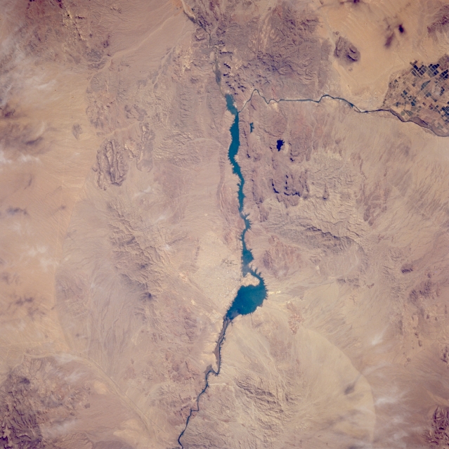 |
| STS066-088-093 Lake Havasu, Arizona, U.S.A. November 1994 The Colorado River makes a dramatic 90-degree turn to the southwest approximately 20 miles (30 kilometers) south of the Lake Havasu City area, which can be located by its proximity to the large peninsula in Lake Havasu (the long, dark feature in the center of the photograph). Parker Dam is not discernible; however, its impact is apparent through the expanse of water retained behind the dam. This section of the Colorado River forms the boundary between Arizona and California. Local mountain ranges include the Whipple Mountains and Sacramento Mountains along the western (California) side of the photograph and the Mohave Mountains with Crossman Peak [5100 feet (1555 meters) above sea level] immediately east of Lake Havasu City in Arizona. |
| Images: | All Available Images Low-Resolution 309k |
|
| Mission: | STS066 |
|
| Roll - Frame: | 88 - 93 |
|
| Geographical Name: | USA-ARIZONA |
|
| Features: | HAVASU LAKE,COLORADO R. |
|
| Center Lat x Lon: | 34.5N x 114.5W |
|
| Film Exposure: | N | N=Normal exposure, U=Under exposed, O=Over exposed, F=out of Focus |
| Percentage of Cloud Cover-CLDP: | 0 |
|
| Camera:: | HB |
|
| Camera Tilt: | 23 | LO=Low Oblique, HO=High Oblique, NV=Near Vertical |
| Camera Focal Length: | 250 |
|
| Nadir to Photo Center Direction: | N | The direction from the nadir to the center point, N=North, S=South, E=East, W=West |
| Stereo?: | N | Y=Yes there is an adjacent picture of the same area, N=No there isn't |
| Orbit Number: | 34 |
|
| Date: | 19941105 | YYYYMMDD |
| Time: | 185401 | GMT HHMMSS |
| Nadir Lat: | 33.4N |
Latitude of suborbital point of spacecraft |
| Nadir Lon: | 114.8W |
Longitude of suborbital point of spacecraft |
| Sun Azimuth: | 171 | Clockwise angle in degrees from north to the sun measured at the nadir point |
| Space Craft Altitude: | 163 | nautical miles |
| Sun Elevation: | 40 | Angle in degrees between the horizon and the sun, measured at the nadir point |
| Land Views: | MOUNTAIN |
|
| Water Views: | LAKE, RIVER |
|
| Atmosphere Views: | |
|
| Man Made Views: | |
|
| City Views: | |
|
Photo is not associated with any sequences | ||
| NASA Home Page |
JSC Home Page |
JSC Digital Image Collection |
Earth Science & Remote Sensing |
|
This service is provided by the International Space Station program and the JSC Earth Science & Remote Sensing Unit, ARES Division, Exploration Integration Science Directorate.

|