
Geographic Region: RUSSIAN FEDERATION
Feature: RES, PROLETARSK AREA
|
Geographic Region: RUSSIAN FEDERATION Feature: RES, PROLETARSK AREA |
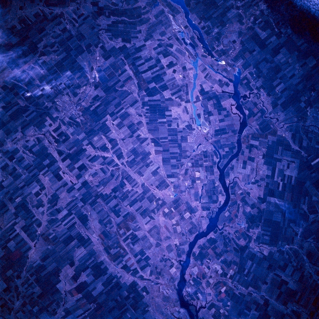 |
| STS066-082-017 Tsimlyansk Reservoir, Russia November 1994 The Don River, located in southwest Russia, has been dammed creating the Tsimlyansk Reservoir (dark feature center of image). The Don River through a series of canals connects the Caspian Sea (through the Volga River) to the Black Sea. Two distinct outlets from the reservoir are visible as winding, dark features (lower right) at the western end of the reservoir. The southerly water feature is a canal and the paralleling meandering stream channel is the original Don River channel. Practically all of the land in this image is used for farming (large angular field patterns) except the large peninsula (upper left) where sandy soils are not conducive for agriculture. Due to the late autumn data acquisition timeframe of this image, healthy green field crops (vegetation) that are usually depicted in various shades of red on color infrared film are not discernible on this image. Recent snowfall obscures some cultivated fields (white areas, upper right corner). |
| Images: | All Available Images Low-Resolution 396k |
|
| Mission: | STS066 |
|
| Roll - Frame: | 82 - 17 |
|
| Geographical Name: | RUSSIAN FEDERATION |
|
| Features: | RES, PROLETARSK AREA |
|
| Center Lat x Lon: | 47.0N x 41.5E |
|
| Film Exposure: | N | N=Normal exposure, U=Under exposed, O=Over exposed, F=out of Focus |
| Percentage of Cloud Cover-CLDP: | 0 |
|
| Camera:: | HB |
|
| Camera Tilt: | 17 | LO=Low Oblique, HO=High Oblique, NV=Near Vertical |
| Camera Focal Length: | 250 |
|
| Nadir to Photo Center Direction: | SW | The direction from the nadir to the center point, N=North, S=South, E=East, W=West |
| Stereo?: | N | Y=Yes there is an adjacent picture of the same area, N=No there isn't |
| Orbit Number: | 75 |
|
| Date: | 19941108 | YYYYMMDD |
| Time: | 084856 | GMT HHMMSS |
| Nadir Lat: | 47.7N |
Latitude of suborbital point of spacecraft |
| Nadir Lon: | 41.9E |
Longitude of suborbital point of spacecraft |
| Sun Azimuth: | 178 | Clockwise angle in degrees from north to the sun measured at the nadir point |
| Space Craft Altitude: | 161 | nautical miles |
| Sun Elevation: | 26 | Angle in degrees between the horizon and the sun, measured at the nadir point |
| Land Views: | |
|
| Water Views: | RESERVOIR |
|
| Atmosphere Views: | |
|
| Man Made Views: | AGRICULTURE |
|
| City Views: | |
|
Photo is not associated with any sequences | ||
| NASA Home Page |
JSC Home Page |
JSC Digital Image Collection |
Earth Science & Remote Sensing |
|
This service is provided by the International Space Station program and the JSC Earth Science & Remote Sensing Unit, ARES Division, Exploration Integration Science Directorate.

|