
Geographic Region: RUSSIAN FEDERATION
Feature: MOUTH OF DON RIVER
|
Geographic Region: RUSSIAN FEDERATION Feature: MOUTH OF DON RIVER |
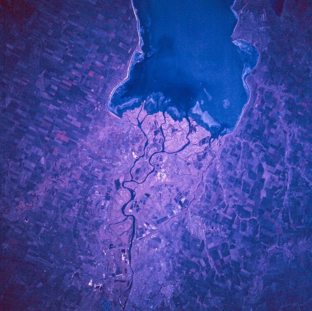 |
| STS066-082-011 Rostov-On-Don, Russia November 1994 The large city of Rostov-On-Don (over 1 million people) is located in southwest Russia approximately 30 miles (50 km) from the mouth of the Don River delta. Rostov (bottom center) is the industrial, scientific, and cultural center of the North Caucasus Region. The large feature (top center) is the eastern end of Taganrogskiy Bay, which is an inlet to the Sea of Azov. Several distributary channels of the Don River (westward draining) fan out to create a low-lying, swampy delta (lighter-shaded area, center of image), immediately west of Rostov. Several airport runways (linear, light-colored features) are visible in the Rostov area: one runway can be identified south of Rostov (lower left) and two runways are visible near the town of Taganrog which is located west of Rostov and along the north side of the bay (upper right). Large cultivated field patterns (angular-looking features) north and south of the Don River indicates an agricultural landscape. The reddish color that is associated with healthy, green vegetation is subdued on this late autumn color infrared image. |
| Images: | All Available Images Low-Resolution 383k |
|
| Mission: | STS066 |
|
| Roll - Frame: | 82 - 11 |
|
| Geographical Name: | RUSSIAN FEDERATION |
|
| Features: | MOUTH OF DON RIVER |
|
| Center Lat x Lon: | 47.0N x 39.0E |
|
| Film Exposure: | N | N=Normal exposure, U=Under exposed, O=Over exposed, F=out of Focus |
| Percentage of Cloud Cover-CLDP: | 0 |
|
| Camera:: | HB |
|
| Camera Tilt: | 18 | LO=Low Oblique, HO=High Oblique, NV=Near Vertical |
| Camera Focal Length: | 250 |
|
| Nadir to Photo Center Direction: | NW | The direction from the nadir to the center point, N=North, S=South, E=East, W=West |
| Stereo?: | Y | Y=Yes there is an adjacent picture of the same area, N=No there isn't |
| Orbit Number: | 75 |
|
| Date: | 19941108 | YYYYMMDD |
| Time: | 084825 | GMT HHMMSS |
| Nadir Lat: | 46.4N |
Latitude of suborbital point of spacecraft |
| Nadir Lon: | 39.6E |
Longitude of suborbital point of spacecraft |
| Sun Azimuth: | 175 | Clockwise angle in degrees from north to the sun measured at the nadir point |
| Space Craft Altitude: | 161 | nautical miles |
| Sun Elevation: | 27 | Angle in degrees between the horizon and the sun, measured at the nadir point |
| Land Views: | |
|
| Water Views: | DELTA, RIVER, BAY |
|
| Atmosphere Views: | |
|
| Man Made Views: | AGRICULTURE |
|
| City Views: | |
|
Photo is not associated with any sequences | ||
| NASA Home Page |
JSC Home Page |
JSC Digital Image Collection |
Earth Science & Remote Sensing |
|
This service is provided by the International Space Station program and the JSC Earth Science & Remote Sensing Unit, ARES Division, Exploration Integration Science Directorate.

|