
Geographic Region: USA-MISSISSIPPI
Feature: MISSISSIPPI RIVER
|
Geographic Region: USA-MISSISSIPPI Feature: MISSISSIPPI RIVER |
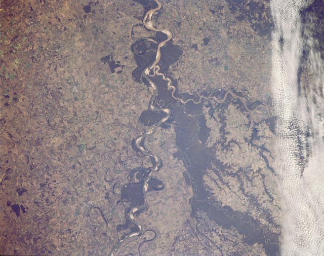 |
| STS066-158-095 Mississippi River Floodplain, Arkansas, U.S.A. November 1994 The meandering Mississippi River with large white sandbars and a broad floodplain are featured in this south-looking photograph of the Mississippi River Valley. Numerous cultivated field patterns confirm that this fertile floodplain is a region of extensive agriculture. Two meandering rivers merge with the Mississippi River from the west--the broad Arkansas River and the narrow White River, which seems to have developed its own floodplain of dark forested land on either side. A narrow band of clouds overhangs to the west. |
| Images: | All Available Images Low-Resolution 126k |
|
| Mission: | STS066 |
|
| Roll - Frame: | 158 - 95 |
|
| Geographical Name: | USA-MISSISSIPPI |
|
| Features: | MISSISSIPPI RIVER |
|
| Center Lat x Lon: | 34.0N x 91W |
|
| Film Exposure: | N | N=Normal exposure, U=Under exposed, O=Over exposed, F=out of Focus |
| Percentage of Cloud Cover-CLDP: | 10 |
|
| Camera:: | LH |
|
| Camera Tilt: | LO | LO=Low Oblique, HO=High Oblique, NV=Near Vertical |
| Camera Focal Length: | 250 |
|
| Nadir to Photo Center Direction: | The direction from the nadir to the center point, N=North, S=South, E=East, W=West |
|
| Stereo?: | N | Y=Yes there is an adjacent picture of the same area, N=No there isn't |
| Orbit Number: | |
|
| Date: | 199411__ | YYYYMMDD |
| Time: | GMT HHMMSS |
|
| Nadir Lat: | N |
Latitude of suborbital point of spacecraft |
| Nadir Lon: | E |
Longitude of suborbital point of spacecraft |
| Sun Azimuth: | Clockwise angle in degrees from north to the sun measured at the nadir point |
|
| Space Craft Altitude: | nautical miles |
|
| Sun Elevation: | Angle in degrees between the horizon and the sun, measured at the nadir point |
|
| Land Views: | FLOOD PLAIN |
|
| Water Views: | RIVER |
|
| Atmosphere Views: | |
|
| Man Made Views: | AGRICULTURE |
|
| City Views: | |
|
Photo is not associated with any sequences | ||
| NASA Home Page |
JSC Home Page |
JSC Digital Image Collection |
Earth Science & Remote Sensing |
|
This service is provided by the International Space Station program and the JSC Earth Science & Remote Sensing Unit, ARES Division, Exploration Integration Science Directorate.

|