
Geographic Region: USA-KENTUCKY
Feature: KENTUCKY LAKE AREA
|
Geographic Region: USA-KENTUCKY Feature: KENTUCKY LAKE AREA |
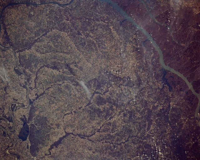 |
| STS066-158-102 Western Kentucky, U.S.A. November 1994 Featured in this photograph of western Kentucky are three bodies of water--from west to east, the meandering Mississippi River with lighter sandbars in its main channel, the Ohio River, and Kentucky Lake. A small section of the Ohio River, which merges with the Mississippi River just beyond the scope of this photograph, is apparent (top left). Long, wide Kentucky Lake appears farthest east. The dendritic drainage pattern shows that most of the land between the Mississippi River and Kentucky Lake drains westward into the Mississippi River. |
| Images: | All Available Images Low-Resolution 301k |
|
| Mission: | STS066 |
|
| Roll - Frame: | 158 - 102 |
|
| Geographical Name: | USA-KENTUCKY |
|
| Features: | KENTUCKY LAKE AREA |
|
| Center Lat x Lon: | 36.5N x 88.5W |
|
| Film Exposure: | N | N=Normal exposure, U=Under exposed, O=Over exposed, F=out of Focus |
| Percentage of Cloud Cover-CLDP: | 5 |
|
| Camera:: | LH |
|
| Camera Tilt: | LO | LO=Low Oblique, HO=High Oblique, NV=Near Vertical |
| Camera Focal Length: | 250 |
|
| Nadir to Photo Center Direction: | The direction from the nadir to the center point, N=North, S=South, E=East, W=West |
|
| Stereo?: | N | Y=Yes there is an adjacent picture of the same area, N=No there isn't |
| Orbit Number: | |
|
| Date: | 199411__ | YYYYMMDD |
| Time: | GMT HHMMSS |
|
| Nadir Lat: | N |
Latitude of suborbital point of spacecraft |
| Nadir Lon: | E |
Longitude of suborbital point of spacecraft |
| Sun Azimuth: | Clockwise angle in degrees from north to the sun measured at the nadir point |
|
| Space Craft Altitude: | nautical miles |
|
| Sun Elevation: | Angle in degrees between the horizon and the sun, measured at the nadir point |
|
| Land Views: | |
|
| Water Views: | RIVER, LAKE |
|
| Atmosphere Views: | |
|
| Man Made Views: | |
|
| City Views: | |
|
Photo is not associated with any sequences | ||
| NASA Home Page |
JSC Home Page |
JSC Digital Image Collection |
Earth Science & Remote Sensing |
|
This service is provided by the International Space Station program and the JSC Earth Science & Remote Sensing Unit, ARES Division, Exploration Integration Science Directorate.

|