
Geographic Region: TURKEY
Feature: ISTANBUL, SEA OF MARMARA
|
Geographic Region: TURKEY Feature: ISTANBUL, SEA OF MARMARA |
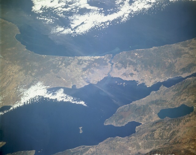 |
| STS066-157-192 The Bosporus, Turkey November 1994 The Bosporus (near the center of the photograph), a strait that connects the Black Sea to the north with the Sea of Marmara to the south, stands out in this low-oblique, north-looking photograph. One of the world's most strategic waterways, the strait separates European Turkey to the west with Asiatic Turkey to the east. Structurally the Bosporus is an inundated valley that follows an irregular northeast-southwest course 19 miles (30 kilometers) long, with widths varying from approximately 2 miles (4 kilometers) at its northern mouth to 800 yards (730 meters) at Rumelihasari, midway of the strait. The current flows north to south; however, a strong subsurface countercurrent with numerous points and coves sets up swirls and eddies that make navigation dangerous to the inexperienced. Istanbul (formerly Constantinople), one of the great historic cities of the world, sits near the Bosporus entrance to the Sea of Marmara. A city of more than 3 million people, Istanbul is Turkey's major seaport as well as its commercial, financial, and cultural center. The city, like Rome, is built on seven hills. Major industries include shipbuilding, tobacco, textiles, glass products, leather goods (especially shoes), cement, and tourism. The European (western) side of Istanbul is the terminus of an international rail service formerly called the Orient Express. The Bosporus Bridge, connecting the European and Asian sections of the city, was opened in 1973 and is one of the longest suspension bridges in the world [3524 feet (1074 meters)]. |
| Images: | All Available Images Low-Resolution 86k |
|
| Mission: | STS066 |
|
| Roll - Frame: | 157 - 192 |
|
| Geographical Name: | TURKEY |
|
| Features: | ISTANBUL, SEA OF MARMARA |
|
| Center Lat x Lon: | 41.0N x 29.0E |
|
| Film Exposure: | N | N=Normal exposure, U=Under exposed, O=Over exposed, F=out of Focus |
| Percentage of Cloud Cover-CLDP: | 10 |
|
| Camera:: | LH |
|
| Camera Tilt: | 42 | LO=Low Oblique, HO=High Oblique, NV=Near Vertical |
| Camera Focal Length: | 250 |
|
| Nadir to Photo Center Direction: | N | The direction from the nadir to the center point, N=North, S=South, E=East, W=West |
| Stereo?: | Y | Y=Yes there is an adjacent picture of the same area, N=No there isn't |
| Orbit Number: | 75 |
|
| Date: | 19941108 | YYYYMMDD |
| Time: | 084528 | GMT HHMMSS |
| Nadir Lat: | 38.6N |
Latitude of suborbital point of spacecraft |
| Nadir Lon: | 28.7E |
Longitude of suborbital point of spacecraft |
| Sun Azimuth: | 162 | Clockwise angle in degrees from north to the sun measured at the nadir point |
| Space Craft Altitude: | 160 | nautical miles |
| Sun Elevation: | 33 | Angle in degrees between the horizon and the sun, measured at the nadir point |
| Land Views: | COAST, MOUNTAIN, PENINSULA |
|
| Water Views: | SEA, STRAIT, BAY |
|
| Atmosphere Views: | |
|
| Man Made Views: | URBAN AREA |
|
| City Views: | ISTANBUL |
|
Photo is not associated with any sequences | ||
| NASA Home Page |
JSC Home Page |
JSC Digital Image Collection |
Earth Science & Remote Sensing |
|
This service is provided by the International Space Station program and the JSC Earth Science & Remote Sensing Unit, ARES Division, Exploration Integration Science Directorate.

|